Select to expand quoteMarkSSC said..
The pictures seem to show a narrowing of the channel at Happy Valley. Perhaps if it closes off there we will have an enclosed flat water blasting area without the run-out tide and wind obstructions when it is easterly.
I sailed at GB recently, just after the break through, when the tide was about 30 cm above normal levels. I lauched about midway between the lighthouse and the jetty before the GB swimming area. The sandbanks were well and truly covered. There was a tiny tiny bit of messy swell which was useful when needing a little help to get on the plane. The wind was still a bit up and down, as per usual. When the tide started going out a lot of branches and grass started drifting past towards Bulcock Beach (much the same speed it always has).
On the down side, the showers in picnic areas now have fancy taps that automatically turn off after about 10 secs. To wash your stuff you have to keep pressing the button every few seconds. There is no longer a tap to connect your hose to!
the old speed strip used to run south to north from the toilets up to the boardwalk along the bank. was killer in an easterly being completely open to the wind.
was thinking the same thing about a bay forming too. would be nice.
Select to expand quoteGestalt said..
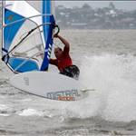
some new photos on blueys facebook... and oh my... have we been gifted.
this one photos speaks volumes.

Just noticed this photo also shows the Mare's Tails meaning the SE'r is coming.
Oh yay, a bay with trees n buildings surrounding it. Thatll make a top sailing spot....
Better bring yr chainsaws.![]()
Select to expand quoteolskool said..
Oh yay, a bay with trees n buildings surrounding it. Thatll make a top sailing spot....
Better bring yr chainsaws.![]()
won't be a large change from now then.. lol.
it's already called golden pond.... ![]()
who knows what will happen. i reckon it will just keep changing as it has forever. a new strip will probably form somewhere further south where the wind is better.
Mabee I could become an agent for Fangy and open a stall at Golden pond![]()
Grippiest shallow water fin ever .
The 28 cm has more than enough grip for a 9.4 with big me and big board .
Select to expand quoteolskool said..
Oh yay, a bay with trees n buildings surrounding it. Thatll make a top sailing spot....
Better bring yr chainsaws.![]()
I was thinking of the bank way out from the shore where Happy Valley is. In an easterly, the buildings and trees of Bribie would not affect it. This only works if the tidal channel closes, and enough water still covers the sandbanks. Might need a 28 cm fin or skim board!
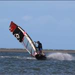
Photos make it look as if the break is growing each day. Is that the case?
(stolen from the Courier Fail)

Select to expand quotemkseven said..
Has anyone sailed it yet?
yep a few have. all report it's still fairly messy.
a few of us are trying to figure out best time to try waves there. trying to make sure of an incoming tide to reduce the risk.
most photos seem to be taken around high tide. i'm thinking low to mid might be best. am looking to sail there on a longboard this weekend at low tide to check things out. depends on kids sport.
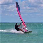
looking at the photos the southern bank in a northerly looks enticing.
best bit in my mind, it's the buildings and the trees that have spoilt the pond so this may breath new life into the area for wind sports. certainly looks promising enough for me to consider driving there every weekend. also likely get all the crew back in the same spot, slalom, speed, freestyle and waves.
last time i hit the pond it was 10 knots there and 20+ at mooloolaba. didn't really bother with it much more after that unless on my LT or with friends.
The sandbank between Gemini n the new bar gets a stronger more even Northerly wind than our normal sailing zone.More water over that bank on the High tides now. Time to break out the Fangy fins.
Select to expand quoteolskool said..
The sandbank between Gemini n the new bar gets a stronger more even Northerly wind than our normal sailing zone.More water over that bank on the High tides now. Time to break out the Fangy fins.
good times ahead.
Select to expand quotemkseven said..
Has anyone sailed it yet?
Tidal water movement through the break would be interesting
Select to expand quoteJohn340 said..mkseven said..
Has anyone sailed it yet?
Tidal water movement through the break would be interesting
Road trip![]()
Select to expand quoteJohn340 said..mkseven said..
Has anyone sailed it yet?
Tidal water movement through the break would be interesting
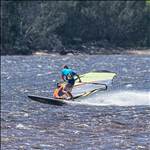
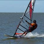
Just sailed it today at high tide. Water is very messy when you're close to the shore but becomes smoother when you get out into the waves. Lots of nice little ramps to jump off of ![]() I should have taken some video with the GoPro today... If anyone is planning on checking out the new bar, tomorrow and Sunday both look promising. Wind was howling today earlier on!
I should have taken some video with the GoPro today... If anyone is planning on checking out the new bar, tomorrow and Sunday both look promising. Wind was howling today earlier on!
Select to expand quoteolskool said..
The sandbank between Gemini n the new bar gets a stronger more even Northerly wind than our normal sailing zone.More water over that bank on the High tides now. Time to break out the Fangy fins.
What is a fangy fin?
Select to expand quoteDJMax said..John340 said..mkseven said..
Has anyone sailed it yet?
Tidal water movement through the break would be interesting
Just sailed it today at high tide. Water is very messy when you're close to the shore but becomes smoother when you get out into the waves. Lots of nice little ramps to jump off of ![]() I should have taken some video with the GoPro today... If anyone is planning on checking out the new bar, tomorrow and Sunday both look promising. Wind was howling today earlier on!
I should have taken some video with the GoPro today... If anyone is planning on checking out the new bar, tomorrow and Sunday both look promising. Wind was howling today earlier on!
Nice!!!
Select to expand quoteMarkSSC said..olskool said..
The sandbank between Gemini n the new bar gets a stronger more even Northerly wind than our normal sailing zone.More water over that bank on the High tides now. Time to break out the Fangy fins.
What is a fangy fin?
Fangy made some short meaty cast aluminium fins:
www.seabreeze.com.au/forums/Windsurfing/Gps/FangyFin-DIY-help--hints-and-show-us-ya-fin-page?page=1
Select to expand quoteGasHazard said..MarkSSC said..olskool said..
The sandbank between Gemini n the new bar gets a stronger more even Northerly wind than our normal sailing zone.More water over that bank on the High tides now. Time to break out the Fangy fins.
What is a fangy fin?
Fangy made some short meaty cast aluminium fins:
www.seabreeze.com.au/forums/Windsurfing/Gps/FangyFin-DIY-help--hints-and-show-us-ya-fin-page?page=1
For use in shallow and or weedy spots. They are 45 to 50 degrees. You can use a 24cm Fangy fin with a 115lt ? 72cm board
Select to expand quoteShifu said..
Photos make it look as if the break is growing each day. Is that the case?
(stolen from the Courier Fail)
G'day Ian, It has been changing everyday until about 2 days ago, although I am only looking from the GB shore. Any pics you see in mainstream media won't be current.
Select to expand quoteShifu said..
Photos make it look as if the break is growing each day. Is that the case?
(stolen from the Courier Fail)
I filmed a video of it on Saturday. It wasn't windy enough for windsurfing so I had to wingding ![]()
But if anyone wants to see the gap up close, this is probably one of the best videos
Select to expand quoteDJMax said..Shifu said..
Photos make it look as if the break is growing each day. Is that the case?
(stolen from the Courier Fail)
I filmed a video of it on Saturday. It wasn't windy enough for windsurfing so I had to wingding ![]()
But if anyone wants to see the gap up close, this is probably one of the best videos
Fascinating!