Maila: Landfall Monday, Final Warning
In short
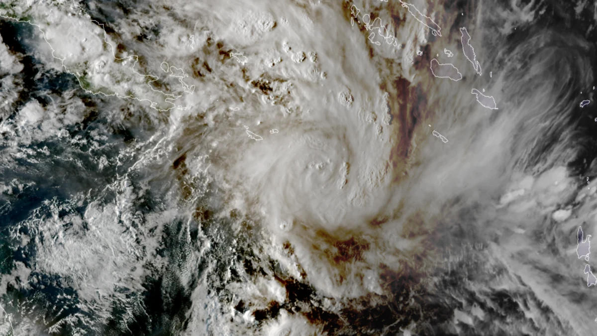
Tropical Cyclone Maila — which peaked at Category 5 with a 924 hPa central pressure over the Solomon Sea — is forecast to cross the Cape York Peninsula on Monday 14 April as a Category 2, possibly Category 3 system.
Catchments from Lockhart River south to Cairns are already saturated from Cyclone Narelle's passage in late March, meaning Maila's rainfall of 200–300 mm will produce flooding significantly worse than either storm in isolation.
What to do now
If your vessel is anywhere between Cairns and Cape York and hasn't been secured or moved, you are out of time. The preparation window closes tonight.
Tropical Cyclone Maila will cross the Cape York Peninsula on Monday 14 April, according to Bureau of Meteorology forecasts current as of Sunday 13 April. The most likely landfall zone runs from Lockhart River north to Cooktown — roughly the same 500-kilometre coastal stretch that has been under a cyclone shadow for the past fortnight. The storm is forecast to arrive as a Category 2, with Category 3 intensity still possible depending on how much the Coral Sea re-energises the system in the final 24 hours before landfall.
Maila's track has not been simple to forecast. The system peaked on 7 April at Category 5 with a central pressure of 924 hPa, the strongest cyclone recorded that far north in the Solomon Sea, according to BOM data — then weakened sharply as it crossed mountainous PNG terrain and churned through cooler upwelled water beneath it. By 12 April, the Solomon Islands Meteorological Service had formally downgraded it to a tropical low, with sustained winds near 30 km/h and central pressure around 1000 hPa. That weakening may have created a false sense of relief. BOM Senior Meteorologist Ilana Cherny warned: "We're now seeing increasing confidence that it's going to move towards the Far North Queensland coast." The Coral Sea surface temperatures ahead of the system are warm enough to support re-intensification, and BOM's forecast is for the system to strengthen as it approaches the coast — not remain a low.
BOM meteorologist Dylan Narramore offered a counterintuitive observation that explains why the FNQ coast has remained relatively dry in the lead-up: "This cyclone [is] sucking all that weather away from the coast due to those southerly winds wrapping around." That dry coastal strip is a temporary condition. When the system arrives Monday, the rainfall pattern reverses hard.
The flooding threat is worse than the wind
Wind is not the main threat from Maila at landfall. BOM Senior Meteorologist Jonathan How stated: "Communities in these areas could see damaging to destructive winds as well as heavy rainfall and flooding and coastal erosion." Daily rainfall totals of 200–300 mm are anticipated in the landfall zone, according to forecasts from Mirage News citing BOM updates. That figure lands on ground that is not remotely dry. Severe Tropical Cyclone Narelle crossed Cape York as a Category 4 system with winds of 225 km/h (121 knots) and a central pressure of 930 hPa in late March — six hPa shallower than Maila's peak, making Maila the deeper system at its worst. Narelle flooded the Northern Peninsula Area, forced extended closure of the Jardine River Ferry (which had not been expected to reopen until 13 April at the earliest — the day before Maila's arrival), and left catchments from the cape's rivers to the Wet Tropics range holding near-saturation moisture. A second major rainfall event arriving on already-saturated ground produces disproportionately worse flooding: the soil cannot absorb, runoff is near-immediate, and rivers that have barely begun to drain can return to peak heights faster than during the original event.
"Communities in these areas could see damaging to destructive winds as well as heavy rainfall and flooding and coastal erosion." — BOM Senior Meteorologist Jonathan How
Storm surge compounds the flooding risk at the coast. Surge magnitude depends on landfall angle, continental shelf bathymetry, forward speed, and tide state — detail that only becomes clear in the final 12 hours of approach. No specific surge heights had been published as of this update; the definitive figures will appear in BOM's formal Storm Tide Warning, which is issued once track confidence is sufficient to resolve surge for individual communities. What is clear now: low-lying estuaries and river mouths along the Cape York east coast — including those used by trailer-boat fishers accessing reef edges — will be impassable during surge. Do not attempt bar crossings in any river or creek entry anywhere between Lockhart River and Cairns until the system has cleared and surge has settled. Monitor Seabreeze warnings for current coastal advisories as BOM updates the surge guidance.
What FNQ boaters and fishers need to do
The window for vessel preparation has effectively closed for in-water boats. Trailerable vessels should have been moved inland before today. If yours hasn't been, move it now: face the bow into the anticipated wind direction, lash to ground anchors with 24 mm diameter rope or chain, lower off the trailer if possible, strip all canvas, electronics, and the outboard. Do not rely on a marina pen as your primary strategy unless that marina holds an active cyclone rating and your insurance policy specifies cyclone-rated marina coverage for named events — check your product disclosure statement before leaving the vessel there.
Offshore passages are finished until post-landfall. The Coral Sea is carrying swell generated by Maila's large circulation well ahead of its centre. Liveaboard dive operators from Cairns and Port Douglas accessing Osprey Reef, Bougainville Reef, and the Ribbon Reefs should have turned back already. After Maila crosses, allow a minimum of 48–72 hours for the sea state to settle before attempting any offshore passage from FNQ ports — and longer before attempting to anchor on exposed reef walls.
The estuarine and inshore fishery will be disrupted for a week or more. April is normally the opening of the Cape York reef edge for trailer-boat fishers chasing Spanish mackerel and coral trout. Maila's rainfall will deliver significant fresh water to every major river system between Lockhart River and the Daintree, dropping salinity sharply across estuaries that hold barramundi, mangrove jack, and flathead. Fish will retreat from their usual holding structure in response to the freshwater push. Post-flood fishing can produce good results as conditions normalise — but that's a week away at minimum. The immediate priority is securing gear, not planning sessions.
Track uncertainty remains — but the risk window is symmetric
BOM Senior Meteorologist Liam Smart noted the forecast difficulty plainly: "Normally there are steering winds from the east or west but, in this case, there aren't any." BOM Senior Forecaster Shane Kennedy explained the weakening mechanism: "It should weaken as it interacts with the land around Papua New Guinea, and it crosses over islands." That acknowledged weakening does not reduce the landfall threat — the re-intensification phase in the Coral Sea is what matters now. BOM's Ilana Cherny described the track precision issue: the difference between a near miss and a direct strike "may depend on mere kilometres of landfall variation." Communities from Cairns to the tip of Cape York cannot assume they are outside the impact zone on current track guidance alone. The southern possibility — Cairns — remains within the forecast envelope.
The 2025-26 season context is not reassuring. With 11 named cyclones and seven reaching severe status, this has been one of the most active Australian cyclone seasons on record, according to BOM tracking data. Maila making landfall on Cape York would make it the third cyclone to directly affect the Australian mainland this season. The sustained elevated sea surface temperatures across the Coral Sea that drove Maila to its 924 hPa peak and Narelle to 930 hPa have not yet moderated. The forecast for the coming days includes continued warm SSTs in the path of the system, which is why BOM has not discounted a Category 3 landfall.
On pre-existing damage from Narelle: no dive operator reports or charter captain assessments of the northern reef system's condition post-Narelle were publicly available as of this update. The physical state of inshore reef structures, moorings, and known fishing grounds between Lockhart River and Cairns after Narelle's Category 4 passage has not been documented in accessible reports. Maila arriving before that assessment can happen is a compounding factor that the recreational sector will need to work through once conditions allow re-entry.
Questions
What time on Monday is landfall expected? BOM's best-track as of Sunday places landfall during Monday, but the exact timing had not been resolved to a specific hour window in available forecasts. Six-hourly BOM tropical advisories will narrow this through Sunday night into Monday morning. Track the system via Seabreeze marine forecasts for the latest updates.
If Maila weakened to a tropical low — why is it still dangerous? The weakening through PNG terrain was a temporary structural disruption to the circulation, not a dissipation. Sea surface temperatures in the Coral Sea are warm enough to support re-intensification. BOM's forecast accounts for this: the Category 2 landfall estimate is not based on the system's current (weakened) state but on its projected state after crossing the Coral Sea in the final 24 hours.
Is the Jardine River Ferry operating? The ferry was not expected to resume until 13 April at the earliest following Narelle's damage, according to reporting by Newsport Daily. Maila's arrival timing makes any resumption on that date moot — the ferry crossing and all river bar entries in the landfall zone should be treated as closed until post-storm assessment.
When can fishing and diving resume after landfall? Sea state and bar safety: minimum 48–72 hours post-passage, longer for offshore. Estuarine fishing: salinity will recover in 5–10 days in most river systems, faster in smaller drainages. Full reef-edge access: dependent on passage clearing the area and an assessment of ramp and access road conditions, some of which may be flooded or cut for longer.
What happened to Cyclone Vaianu? Severe Tropical Cyclone Vaianu — a concurrent Category 3 system east of Fiji — was tracking east of FNQ at the time of writing. Its influence on east coast swell is separate from Maila's surge risk but adds to the total energy in the region's seas. FNQ's marine environment is absorbing swell inputs from two active systems simultaneously.