General gripe...
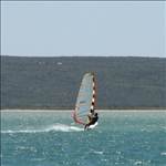
So, we chose to immigrate specifically to Perth, a decision based largely on the strength of the BOM wind rose shown below, which implies that every 3rd day in summer gets 20-30 knot SW winds in the afternoons. Looked like consistent and paradise-like conditions for windsurfing. However, just as I got some equipment, the winds have been mostly offshore easterlies, with forecast for more of the same. Is this normal for here?

yes but it's not all bad.
currently we have a la nina cycle. from what i understand the cycle occurs every 3-5 years and 50% of la nina events are fiollowed by another la nina.
this is the second la nina event in a row for australia so based on the statistics above next year should be back to normal in perth. fingers crossed.......
what happens is during a la nina event the water around northern qld and the gulf heats up more than normal. this pool of warm water from what i understand flows west towards NW WA and then heads south down towards perth.
during la nina events the pool of warm water is bigger and the SE winds on the eastern coast of australia are stronger so more warm water gets pushed towards NW WA and then flows south.
that heats up the water on the coast of WA more than normal and does a couple of things.
firstly, it reduces the temperature difference between the ocean off WA and the deserts inland.
secondly more lows form to the NW of WA and this stops the troughs from heading east and enhancing the seabreezes.
that's my understanding. i could be wrong. hopefully there is a meteorolgist out there that can confirm this.
out of interest this is cairns/norther qld in september. if only we all had the life structure to live half the year in WA and the other half in qld.

i think the worst years for you guys are when there is a lanina and a negative indian ocean diopole or somehting like that.
Thanks for the explanation Gestalt, makes sense. Looks like BOM has pretty advanced modelling the La Nina-related temperature changes, and their projections show gradual return to normal starting now, and finishing by the end of the year: www.bom.gov.au/climate/enso/archive/ensowrap_20120201.pdf
I assume you realise the wind rose is in km/hr not knots.
Genuine 20-30K seabreezes are not common in Perth. I reckon in a good season we get half a dozen.
18-22K is more typical.
Still not bad, but if you want 20-30K 3 times/week move to Gero ![]()
Good point, Pointman - I did assume it was in knots.
This is measured at the airport though, subject to all sort of drag / ground effects - presumably it's a bit more at the coast, especially in the case of onshore winds. 18-22k is a very nice wind range, glad to hear that.
I'll definitely take a drive to Geraldton one of these weekends, but might get lost around the Lancelin area :)
Reasonable explanation Gesty, just to add a bit more, The Southern ocean is also a big determinant of the pressure systems that come across, and apparently, globabl warming means that the stronger southerly flows as they come across with both highs., and lows, are running further south of the continent, meaning we are not getting as many southerly flows, which bring strong seabreezes, so it may be a bit more than la nina and a bit more permanent![]()
As for water temps and seabreezes? A personal observation was in DEc in Shark bay, water temps were about 25 to 27 degrees C, and the seabreezes were much stronger than perth which had 21 to 22 degrees C??? weather forecasting is very complex, chaos theory originated from it i think![]()
This is not unusual weather for this time of year but the troughing we have seen so much of this summer and last is NOT usual. Yes, la nina to blame.
Strong seabreezes 5 days out of 7 is more the norm.
Fingers crossed for next year. XXX
Hardie,
I have been camping in Albany (Nanarup) at Easter for the last 25 years or so and have never been so comfortable swimming there as I have over the last 18 months. The water temp is more like Perth's in the middle of summer - if not warmer !
I was down there two weeks ago and the sea temp is still vverryyy nice.
I'm not holding my breath for many more good seabreezes this summer ![]()
Winter 2009 was one of the best ever.
2010 was the worst ever, and 2011 was somewhere in between.
Have we had a summer worse than this one?
i'm not convinced and not sure in the same breath.
i think la nina pushes the highs further south as it strengthens the sub tropical ridge.
a seabreeze though is a seabreeze. it needs a temperature gradient to form. the west coast trough is the result of the temperature gradient. it's conjecture on my part but it's possible that the trough forms further out to sea during a la nina event.
la nina could also provide too much cloud cover over inland australia which again reduces the temperature gradient.
with the basic setup of the trough the seabreeze is on the western side and the heatwave is on the eastern side. if the trough forms over land then you get seabreezes all day. if the trough forms over the ocean you get heat wave until the trough can move inland. it's the position and creation of the trough that controls your weather during summer.
the bom has some info saying the seabreeze in WA starts with E-NE winds early morning feeding into the trough. i suspect tho if those winds are too strong the trough won't be able to form. i think the magic figure is 20 knots.
then switches SW behind the trough and goes S as the day progresses due to the coriolis effect,
it could also be that with la nina the lows to the NE combined with the highs to the south create a pressure gradient strong enough to stop the trough from heading east. i don't know for sure.
what has me completely baffled is what moves the trough. i would have thought the trough could move under it's own force but articles i've read suggest it needs a cold front between two highs to move east.
anyways, the trough is forecast to return on monday by the bom. it's offshore.
be interesting to see what happens and if you get seabreezes or heatwaves.
This summer seems to be full of troughs which run from Albany up the west coast over the top then down the east

Normally we get a trough which runs part the way up the west coast
did some more reading and i think i understand it now. still it's only my best guess.
but seems hardie was onto it.
La Nina
during la nina periods the moonsonal trough is enhanced which pushes the subtropical ridge further south as low pressure system move further south over northern australia. the enhancing of the monson is driven by the MJO which cycles every 40-60 days and is defined by a pulse of hot moist NW winds across the top end of australia. it moves west to east and gets tracked by cyclone chasers as this same pulse usually means cyclones.
El Nino
the MJO also occurs during el nino cycles but the pulse/moonson is not as strong so the sub tropical ridge sits a little further north and allows blocking highs to sit in the bight bringing droughts to SA and heating up the western parts of WA while enhancing the west coast trough due to a higher temp gradient between the desert and the ocean. the enhanced west coast trough then gets pushed inland by the cold fronts along the subtropical ridge as the highs move west to east. As the subtropical ridge is further north during elnino periods or breaks in the monsoonal trough the cold fronts are in the right position to move the west coast trough inland.
so SA pain = WA gain.
currently there is a break in the monsoonal trough as the mjo moves away. i guess that may mean the return of the seabreeze until end of feb when the mjo returns.
doesn't really mean strong seabreezes though as it is still a la nina cycle so the temp gradients are not as high.
i guess you could look to the mjo when planning road trips etc.
the most dissapointing thing is that Mr sqid still sails more in WA during your bad season then we do on the east coast. ![]()
those charts describe things well,
notice how the ridge of highs to the south is lower so the cold fronts are missing WA. so there is nothing to push the trough inland. it just kind of sits on the coast.
you should get some mild seabreezes monday or tuesday but probably not that strong and short lived.
maybe.
will be interesting to see how it plays out.
What gets me is quite a few times this summer we had the west north est trough which has just lingered for about a week at a time.
Yes that helps explain it more thourough, and its trying to work out the Southern ocean and indean ocean interactions with la nina, but I now see how the monsoonal troughs push the hih pressure systems lower, this helps thanx Gesty