Today I used this www.bom.gov.au/products/IDN60901/IDN60901.94767.shtml
which I think is the same one that seabreeze uses. (Latest Weather Observations for Sydney Airport)
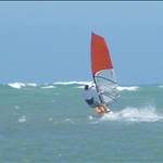
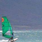
When I left home at 4pm it suggested 15knots N and NNW gusting to 20, when I got to ramsgate at around 5, hardly a ripple on the water, looked about 8knots gusting to 13 tops. Oh well rigged up anyway :-), 6.5 and 100L (and yep no way it was anything like what BOM or seabreeze site says).
Wobled around for an hour, average windspeed I am guessing around 8, came back checked the site, sure enough BOM site still calling 12-14knots average with 17knots gusts.
I have used these sydney airport readings before with NE and Southerly and its seemed much closer to actual conditions, has anyone had this same problem with a northerly or NWester?
Packed up in disgust, but as I drove up the the road noticed the trees moving, pulled over to Kyeemahg to investigate, wind had switched to S, was stacked on 5.5 for an hour, would have kept going but forgot the headlamps... Site showed 24-26knots, gusting to 33, which I reckon was spot on.
The airport meter only works reliably for Nor'Easter and south to south easterly directions. For Northwest look at Kurnell. It's more reliable. As a matter of fact in a Nor'wester Kurnell is the only reliable spot anyway.
Re southerly keep an eye on Kiama and Belambi point meters. It's usually 70 to 90 minutes from the time a change hits kiama to when it reaches botany bay. And more reliably about 45 minutes from Belambi to Botany. Plus the strength for Belambi is usually similar to the strength you will see at the airport. That should allow you to drive to Botany Bay and rig the right sail size before the change arrives. Have done that a million times myself.
I think the sensor is accurate, but it measures at 10m up. It's just that NW is offshore all along the ramsgate -> kyeemagh beach, and the land there is high and not exactly conducive to letting the air flow smoothly onto the water.
Racer,
At least you got to sail in that southerly. It hit a bit later (obviously) on the north side of Sydney and it was still about 33 degrees. I have rigged up after 7pm in the past and you can still get a mad hour on the water.
The North Head reader seems depressingly accurate in a NE, ie; usually no green arrows on seabreeze when Kurnell is a green frenzy!
I also think Kurnell at times gives more realistic readings for BB. I was out last saturday in the NW near the airport, which didn't feel anywhere near as strong as what the airport readings were showing. Kurnell readings were on the money.