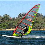
Looks kinda weird to have the smooth water on the outside of the bay, but I guess it opens options for both wind directions ![]()
I remember years ago (when they had a world speed trial at Woodmans point) someone talking about sailing in the salt evaporation pans up north (Denham I think it was). They were trying to set a world record but I think it was the typical thing of no wind as soon as you say that !
I wonder if anyone has ever tried that again ?
I sailed near shark bay about 1988 and remember the water as very flat but when I look at the old photos it looks choppy. I do remember you sailed parrallal to the shore so it felt like you could go as long as you want and never be in more than waster deep water. The only thing that put me of was the sea snakes making eye contact. You could see them on the bottom, lovely S shapes but when I went over the same one a few times he actually poked his head out of the water and looked at me as I went past. Made for fast water starts !!!
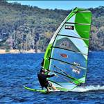
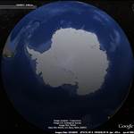
You have a speed venue!!!! Its called Sandy Point![]()
![]() The moment there,s an epic day Slowy and friends are onto their friendly travel agent pleading for extra bagage allowances.[}:)]
The moment there,s an epic day Slowy and friends are onto their friendly travel agent pleading for extra bagage allowances.[}:)]
Last time I passed the the salt evaporation lakes (Lake MCleod) on the way to you know where, there was actually a trench that ran about 3 kms, right direction and everything, only problem was it was only 2 metres wide and a foot deep.
I 'spose you could save up for an excavator and make a West Aussie trench !!!
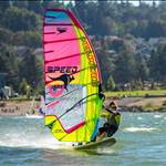
Mal Wright and Co organised a speed event in late 1987 at Useless Loop salt ponds in Shark Bay.
We sailed several ponds, genberally with about 4.9 and 4.4 1987 NP RAF Speeds.
Top speeds were around 34 or 35 knots from memory - all hand timed over surveyed 500m courses.
The angles were a bit too square and to get clean wind you had to sail a fair way out from the levee.
Hot, dry, salty and thirsty work!!


Certainly an amazing spot - 10 minutes worth of surfing:-http://au.babelfish.yahoo.com/translate_url?doit=done&tt=url&intl=1&fr=bf-home&trurl=broke%3A%2F%2Fwww.geocities.com%2Flu7cc%2Ffaro_Punta_Paramo.html&lp=es_en&btnTrUrl=Translate
The dunes to the NW of the spit are actually interspersed with water bodies and if you zoom in right in there are mining activities, incl some open cut stuff - thats perhaps the gold.
If you go into google earth and look to the north, on the coast about 20 km there are 4 white storage tanks running N-S - refinery [enable panoramio] - there is a port [Cullen] there too that deals solely in crude and several offshore platforms - interseting and cold place.
[Not a geologist]
Thanks 25, then I thought maybe the regular dunes are the result of sand mining or something obvious? The earth's crust throws up some pretty organised features for something just shaped by wind and water sloshing about.
Yes the NM is where it's at. It's the fundamental unit of length on water. My best NM yesterday on Lake Pearly Gherkin had 4 gybes and a tack - 11 knots . Don't know what Hardie is complaining about.
After talking extensively to the MI crew and the fastest windsurfer at the Pit, that was the opinion I formed and they concurred. The course is getting too short with the growing sand dunes and the curvature of the course works against you for a 500 m. run. For GPS 10 second runs it is one of the best places in the world but for out and out windsurfing speed records it falls short. Even the MI guys are getting frustrated waiting, it is over 15 years since they first broke the world record there.
We're all protective of our local spots and love to think they are the best in the world so its understandable you may get upset when that opinion is challenged. Even with the Pit at its best the wait for optimum conditions is too long for most people, 2 good days in one year dont increase the odds for breaking records. The kiters understood that and sought out a spot that suited them, windsurfers need to do the same if they have any chance of taking the record back.
I enjoyed my time at Sandy Point and was made to feel most welcome by almost everyone. My family had a fabulous holiday down there and loved the area. To those I had a chance to meet and chat with many thanks for your hospitality.
Roo
burrum heads anyone.
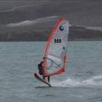
works in any direction and has nearly 5km of flat water to choose from.![]()
reason to learn Russian.Chinese?
www.google.com:443/maps?f=q&hl=en&geocode&q=+lat%3D65.4771240841,+lon%3D-178.572755421&sll=74.54333,85.429688&sspn=24.46063,112.5&ie=UTF8&ll=65.451986,-178.561478&spn=0.138356,0.439453&t=h&z=11
That's a most impressive sand spit Choco. 60km long and 100 metres wide. Maybe it's maintained at a stable width by opposing currents? Has a similar form to the one in Sth America widening out at the very tip. Pt Walter in Perth also has similarities.
Choco, you win but it would be even colder than Punta Paramo. The spit is kept straight by the ocean current (or pack ice at your russian spot).
Pete , they used to mine gold at the Paramo spit.
Roo, yes Slowie did mention you were looking at southern Argentina. It surprised me 'cause I knew someone who sailed the canals of TdF on the Chilian side and the topography was quite hilly, the water freezing and the wind often unsailable. It didn't seem like ideal windsurfing/speed conditions so I had a look at Google Earth.
I think the Chilean and Argentine armies may be your biggest hurdle down there.
Apparantly it is a pretty amazing place from a tourist point of view. Especially the Chilean side.
If we are talking about different spots....
Before they built this lot there was just the channels and no bridges. No Island either.
www.google.com.au:443/maps?f=q&hl=en&geocode&q=doha+qatar&sll=-25.335448,135.745076&sspn=52.786754,114.257813&ie=UTF8&ll=25.353567,51.545105&spn=0.106107,0.22316&t=h&z=13&iwloc=addr

In a northerly Shamal wind the southern channel was sweet as! Just dug out a photo.![]()

The island further out (see google map link)used to give a good run on the opposite tack but you had a long sail home if you broke a fin!
G'day Yoyo,
not as bad in the Magellan Strait as you think, in summer water temp is above 10C and air temp gets up near 15-20C. The local armies are pretty mellow by all accounts, not much trouble after they had the bust up with the Brits over the Falkland/Maldiva Islands! I'll leave my British passport at home if I pop down there. The lower section of TdF is pretty lumpy and bloody cold with the artic current running through there but up north it's very flat and featureless. Contacted a speed sailing buddy down there to see what intel he has on the place, will keep you and Slowey updated.
Roo
I recon' you need to talk to a Marine Hydrologist Ian. Or a Geographer. My theory is that there is a strong north to south current and of course there are prevailing westerly winds. That place certainly seems to have enormous potential given that it is one of the most consistently windy places in the world. NW and SW winds would be pretty close to the best angle and I am sure they are very common. Another advantage of being so far south is that in summer the days will be really long, giving you lots of options to use the best winds and tides.
Of course, a satellite picture is one thing. Getting on the ground to check out the terrain of the sand spit and the depth of the water are another. Looks reasonably accessible though. It looks like evidence of sand mining close by in the satellite images.
That unbelievably long sand spit in north eastern Russia is a different matter. Not sure that you would get suitable winds on that one but there are a couple of smaller ones nearby that might have better winds angles and be more accesable (Although I think that is all relative because that looks mega remote to me).
Wikapedia say of Puna Arenas:
Climate
The seasonal temperature in Punta Arenas is greatly moderated by its proximity to the ocean, with weather.com specifying average lows in July near 1 °C (30.2 °F) and highs in January of 14 °C (57 °F). This is not to say that it is known for stable constant temperatures, only small variability with season. Punta Arenas is also quite dry, with only 43 millimetres (1.7 in) of rain in its wettest month of May. Among Chileans the city is also known for its strong winds (up to 130 km/hour). Winds tend to be strongest during the summer when city officials put up ropes in the downtown area to assist with unique wind currents created by the buildings.![]()
![]()