Sometimes we sail on shallow water, but just may happen that is expectedly too shallow.
Then comes my next invention for windsurfing escapade.
We could attach to the bottom of the board or even better inside the fin - ultrasonic transducer.Connected to electronic control box again. Our ultrasonic depth sonder must be a lot smarter then one used on dumb fishing boats. Our windsurfing depth sounder needs two modes of operation:
1. measure depth below fin
2. forward beam that detect depth in the front of board at some distance ahead
Then we could setup depth when alarm is raised , and our electronic piezo buzzer signalize dangerously shallow water. For example : having less then only 10-20 cm of water below fin should rise our awareness already. Forward looking beam should also advice at least 10 -30 meter ahead water level less then 30 cm.
Smart filter may deal with weeds, if we are going over weedy lake, to detect only hard surfaces, omiss weed. Maybe even detect floating item, crab pot line across. dungeon or turtle. One may say that all those gadgets may cost a lot of money.
Not necessary.
Those sensors and technology is going to be installed on popular drones and there is only matter to adopt them to our needs.
The whole information processing can be done on smart phone, uploaded application do the rest.

And it could be connected to your GPS to log an asterix against any speeds recorded at depths of less than 50cm. That would level the playing field!
Select to expand quoteMacroscien said..
Sometimes we sail on shallow water, but just may happen that is expectedly too shallow.
Then comes my next invention for windsurfing escapade.
We could attach to the bottom of the board or even better inside the fin - ultrasonic transducer.Connected to electronic control box again. Our ultrasonic depth sonder must be a lot smarter then one used on dumb fishing boats. Our windsurfing depth sounder needs two modes of operation:
1. measure depth below fin
2. forward beam that detect depth in the front of board at some distance ahead
Then we could setup depth when alarm is raised , and our electronic piezo buzzer signalize dangerously shallow water. For example : having less then only 10-20 cm of water below fin should rise our awareness already. Forward looking beam should also advice at least 10 -30 meter ahead water level less then 30 cm.
Smart filter may deal with weeds, if we are going over weedy lake, to detect only hard surfaces, omiss weed. Maybe even detect floating item, crab pot line across. dungeon or turtle. One may say that all those gadgets may cost a lot of money.
Not necessary.
Those sensors and technology is going to be installed on popular drones and there is only matter to adopt them to our needs.
The whole information processing can be done on smart phone, uploaded application do the rest.
Those dumb fishing boats you talk of do have forward looking sonar. been around for a while.
You know you could always just understand your area you sail and take precautions when you first head out to know the depth of the bottom.
You just asked for a device that has resolution of about 0.5 degree at 100m.... ie: speed sailing at 50kn, is about 25m/s, and since it takes a few seconds to stop, lets call it 100m. At a depth of 0.5m for 100m, you are looking at 0.58 deg arctan.
If you can build a forward-looking-depth detection of that resolution/capability, then the military will pay handsomely.
i dont know what you are on macro but it must be good stuff.
obviously no wind where you are .
You could map the underwater terrain so you could get a better understanding of where to sail....or more importantly where not to sail! This may allow buoys to be put out in the correct location so you can sail in a safe area.
To take it further you could then link the map to a GPS device and use a geofence around the shallow parts so that it could warn you when you are in such parts.
Further still....clever software should be able to work out if you are heading towards a shallow area and some how warn you so you can turn/stop before you get there.
Its not going to work with sea life though.
Select to expand quotemathew said..
You just asked for a device that has resolution of about 0.5 degree at 100m.... ie: speed sailing at 50kn, is about 25m/s, and since it takes a few seconds to stop, lets call it 100m. At a depth of 0.5m for 100m, you are looking at 0.58 deg arctan.
If you can build a forward-looking-depth detection of that resolution/capability, then the military will pay handsomely.
well, military will pay well , but then will kill me to keep military secrets secret.
Select to expand quoteMacroscien said..mathew said..
You just asked for a device that has resolution of about 0.5 degree at 100m.... ie: speed sailing at 50kn, is about 25m/s, and since it takes a few seconds to stop, lets call it 100m. At a depth of 0.5m for 100m, you are looking at 0.58 deg arctan.
If you can build a forward-looking-depth detection of that resolution/capability, then the military will pay handsomely.
well, military will pay well , but then will kill me to keep military secrets secret.
anyway , after 5 min though I did come to some easy solution regarding resolution.We don't need exact topography in the front, just assurance that there is clearance 0.5 gap at m 50- 100 at front.So our sonar will use two beams that interfere in such way, to give us assurance that returning echo represent this gap in the front,otherwise all signal, interferencje will return quicker that preprogramed distance.
So two transducers at some vertical distance `10-20 cm , all is needed.
Now,
If military want to use that/our technology in secret , needs to:-kill all seabreezers
-bomb our sb server
Select to expand quoteratz said..
obviously no wind where you are .
You are absolutely right.I have my lifetime goals but is looks are not gonna to happen in this reincarnation.
Probability of fulfilling/ creation of
a) weed detector
b) retractable fin
c) depth sounder
in my lifetime
is higher then me
A) making 30ktn NM
B) alpha 25ktn
C) 40ktn 2S
Select to expand quotesrtgumbee said..
You could map the underwater terrain so you could get a better understanding of where to sail....or more importantly where not to sail! This may allow buoys to be put out in the correct location so you can sail in a safe area.
To take it further you could then link the map to a GPS device and use a geofence around the shallow parts so that it could warn you when you are in such parts.
Further still....clever software should be able to work out if you are heading towards a shallow area and some how warn you so you can turn/stop before you get there.
Its not going to work with sea life though.
Yep. Much more practical to just depth map the area before you sail. ![]()
Select to expand quotesailquik said..srtgumbee said..
You could map the underwater terrain so you could get a better understanding of where to sail....or more importantly where not to sail! This may allow buoys to be put out in the correct location so you can sail in a safe area.
To take it further you could then link the map to a GPS device and use a geofence around the shallow parts so that it could warn you when you are in such parts.
Further still....clever software should be able to work out if you are heading towards a shallow area and some how warn you so you can turn/stop before you get there.
Its not going to work with sea life though.
Yep. Much more practical to just depth map the area before you sail. ![]()
some places like our GC are constantly changing in tide. So we use to sail at middle to low tide scratching the sandy bottom frequently,hoping that there is still enough water to get over,Obviously weed fin may be recommended to avoid sudden disappointment. Mapping doesn't help because you know the place perfectly but conditions do change constantly with tide.I did rip whole fin box of my isonic already, but glued it back together- so now is even stronger then ever!Spring swinging back fin will be ideal here !! my work also for crab pots lines
exit speed for someone here is +40ktn, but depth could be 20 cm

I heard also that at places like Lake George knowing local topography is also strongly recommenced in order to avoid hard high speed landing
No type of on board warning system could warn soon enough to avoid hitting. I can think immediately of multiple technical blockers as to why it would not work.
It's and interesting idea, but it is just fantasy. It like saying, gee it would be really sylish to ride a Unicorn. Lets go find one. ![]()
Often, there is just a simpler strategy that works:
One simpler strategy is to walk the course and put in markers.
Another to use a very short high angle/rounded fin that will slide over shallows and weed to reduce impact. At Lake George, the weed is more of an issue to solve than the shallows, and we have multiple excellent solutions to both.


Rather than walk the course putting in markers someone could program a gps to guide you down a verified track through the shallows. A low hum when on track and rising pitch if you veer left or right. You could check out potential speed runs for the given wind direction, tide and shifting sands at a nice sensible speed using a 50cm whisker fin. If all good, lock in the track, bluetooth it to your mates, put in the speed fin and away you go, confident that you've always got enough water to crash in and always within WSSRC approval.
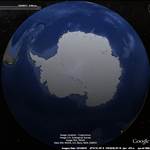
Always nervous sailing in places like Macro's air photo. At sea level it's featureless. You might survive the first run, but you never sail the same line twice so never relax.
Even if you were able to solve the technical problem, at 30 knots, a sailboard travels 15 m/s. If your sonar can detect a shoal 30m away, you have 2 secs to react. As Darryl Kerrigan would say, "Tell him he's dreaming"
For good motorcyclist perception response time (PRT is about 0.70 sec.
www.researchgate.net/publication/241101369_Motorcyclist_perception_response_time_in_stopping_sight_distance_situations
msf-usa.org/downloads/imsc2001/Ecker_01.pdf
(obviously our speed sailor response time we could compare to MotoGP riders not Harley Davidson bikers, with front legs conveniently on steering wheel, and vision obstructed by weeds smoke , although residue beer % in the blood could be similar for both )
even if we may not have enough time to stop completely,awareness of situation may help to prepare, Change position, unhook harness, slow , or suddenly change course, gybe to the safe side, if any.
We could also read this Response Time different way ; now this is 0.7 second later , after you realized the hit something and already flying in the air for those 0.7 sec.
This is a time that you are realized that happily your carbon boom is broken this time, not ribs, mast survid captaput in one piece, but sail wasn't that lucky. Piece of duck tape will help. Depending on the box fin already several meters behind already somewhere in the mud- if single bolt, or something shattered here and there while on tuhle fin.
ok, personal flying drone may help too.
In the place like Lake George.
Fly 100 meters in front and observe the lake with camera (?)
alternatively personal water drone.
small toy boat that remain 100 meters at front , my guiade you if need , and detect water depth.
but for most of the time setup to remain in straight line to your board, in front
Select to expand quoteIan K said..
Rather than walk the course putting in markers someone could program a gps to guide you down a verified track through the shallows. A low hum when on track and rising pitch if you veer left or right. You could check out potential speed runs for the given wind direction, tide and shifting sands at a nice sensible speed using a 50cm whisker fin. If all good, lock in the track, bluetooth it to your mates, put in the speed fin and away you go, confident that you've always got enough water to crash in and always within WSSRC approval.
Always nervous sailing in places like Macro's air photo. At sea level it's featureless. You might survive the first run, but you never sail the same line twice so never relax.
Not totally unrealistic, except that most GPS tack point locations can easily be 3 or 4 meters off on any given run. I think you would still have to reconnoiter the path to extablish the safe track and that may not help you if the tide drops.
WSSRC min depth rule is virtually irrelevant for windsurfers. Even at Luderitz it was routinely...um... 'overlooked.' My memory is a bit fuzzy on it, but I thought it was established that for depth to influence speed significantly, the depth has to be less than half the hull width. For me that is less than 20cm. Frankly, I certainly consider it irrelevant.
Select to expand quotesailquik said..
.WSSRC min depth rule is virtually irrelevant for windsurfers. Even at Luderitz it was routinely...um... 'overlooked.' My memory is a bit fuzzy on it, but I thought it was established that for depth to influence speed significantly, the depth has to be less than half the hull width. For me that is less than 20cm. Frankly, I certainly consider it irrelevant.
Every now and then I google "WSSRC" and "ground effect" looking for another rationalisation of my shallow water phobia![]()
Nothing new has turned up on the internet since we last wrapped up the subject in 2008!
www.seabreeze.com.au/forums/Windsurfing/Gps/water-depth-rule?page=1
Even then the WSSRC couldn't get their story on full or half a beam depth consistent.
www.sailspeedrecords.com/news/58-wssr-newsletter-no-156-water-depth-rule-050708
I suppose what has turned up since, given the millions of shallow water miles subsequently travelled, is that it's not as dangerous as I'd first imagined way back then.
Depth sounding? I had used the glide in the gybe as my early warning that I was sailing a bit thin and maybe should move out an extra hundred metres or so from the Primbee shoreline.
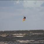
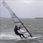
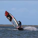
Ahh...., the fear of shallow water. Now that is highly relatable. ![]() By far my worst crashes have been hitting the bottom at speed unexpectedly.
By far my worst crashes have been hitting the bottom at speed unexpectedly. ![]()
![]()
But yes, it turns out that crashing in water that is fin deep, or a little less, is not a big risk. I can tell you from considerable experience, that at fast speeds one rarely penetrates the surface much at all. ![]()
Select to expand quotesailquik said..
Ahh...., the fear of shallow water. Now that is highly relatable. ![]() By far my worst crashes have been hitting the bottom at speed unexpectedly.
By far my worst crashes have been hitting the bottom at speed unexpectedly. ![]()
![]()
But yes, it turns out that crashing in water that is fin deep, or a little less, is not a big risk. I can tell you from considerable experience, that at fast speeds one rarely penetrates the surface much at all. ![]()
that is the concept I have been testing recently. Crashing at high speed at shallow water.
Conclusions from the experiment.
I was quite comfortably flying with my harness lines stil attached.
30 ktn enrty speed
Landing on the sail softly.
Not damage to sail here.But after further investigation i did found those two:
- top batten on the sail dg in into sand and broke in half on my 7.0 Reflex-
- carbon boom mounts to the mast get loosed. It looks that take all the force of harness lines. Now my Severne
boom attachment is swinging sideways freely. Needs further investigation of what happened here.
PS. Fin 30cm Pointer, water 10 cm deep, but that sandy not rocky