Looking promising for Sunday arvo (good tide). Spot on angle forecast my Meteye, which I am starting to trust to be better than some other models. Saying 25-30 knots, so not extreme but should be good for 40Kt runs.
Then after being too WNW Monday morning, it looks like the late afternoon angle will again be spot on, and possibly slightly stronger.
Low tide is forecast for 2.30pm Sunday, and 3.30pm Monday. That should be great for Sunday, but may be just a bit too early for Monday unless the wind swings earlier than currently forecast.
If you are interested, keep an eye on the Meteye updates aver the next 24 hrs.![]()
www.bom.gov.au/australia/meteye/
Sandy Point postcode is 3959 to enter into MetEye.
Still looking good for Sunday @ WSW. Too NW for Monday until late afternoon swing to WSW, but then the tide will be coming in. May still be OK though.
Thanks for info & updates. I am driving 5hr from Yarrawonga early Sunday. First time to Sandy Point.
11.30 pm Saturday evening and latest updates still look very good for Sunday.
Not looking so good for Monday now. Looks like it will stay too WNW for too long and only switch to WSW when the tide has got too high.
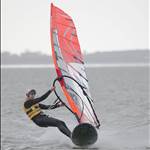
Well it was good fun with a truckload of wind at times, but the speeds were very hard to come by. It did start WSW 20-25 on Sunday, but quickly shifted too far west as it picked up and therefore too broad for good speeds. 39 was tops for me. But we had a bit of fun anyhow and even had a blast up the Yanakie channel ![]()
Monday was WNW as forecast and quite strong, gusting over 40 Knots regularly on the Yanakie AWS! We had a fun sail on the car park to Boathole Entrance sandbar in very gusty winds ranging 20-30kts with brief bullet gusts to 40'ish. Again, very square and speeds only in the mid 30's, but great fun anyhow.
The required wind angle has got much more narrow than it used to be. It's kind of WSW or nothing now. Hoping we get the right one soon. ![]()