Roo emailed me the following:
The idiots guide to using a GPS, by the biggest idiot of them all…..Roo.......
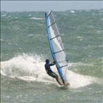
So you want sail fast…..real fast. Not the usual BaFing (Backwards and Forwards) but real balls to the wall...off the wind sailing. If you’re really serious….take a deep breath, clench your butt cheeks, turn the board at least 110 degrees off the wind, sheet in and hold on. Five hundred meters later you may be the new world speed record holder, but how will you know unless you’ve entered one of the three ISA speed contests to be held this year or there’s a GPS receiver strapped to your arm. Glancing down at the screen if you see a number higher than 40 knots you know you’re seriously quick, any less and you’ve got some work to do. That number on the screen is just the beginning, inside the GPS is a record of all your runs and, with careful analysis, the key to making you the Speedy Gonzalez of your beach.
Choosing a GPS is your first step. What you need is a unit that saves a track log of your runs and can record your position every second. You also need to ask yourself how serious you are about analysing and improving your speeds.
If you’re a recreational sailor who just wants to take a few beers off your mates in informal speed contests then something like the Garmin Foretrex 101 or 201 and Gecko is ideal for your needs. While the box it came in tells you its waterproof don’t be fooled, you need an Aquapac to protect the GPS and keep the water out. The Aquapac Pro Sports Mini is ideal, it comes with an arm band so you can strap it onto your forearm or bicep and watch the speed as you sail. The Foretrex comes with a cradle for recharging the battery and downloading data via a serial port on your computer. If you have a newer PC you may need a Serial/USB adapter to allow you to download the track log. The Garmin is fairly old technology so has a built in error that varies your speed somewhat, over longer runs it averages out but for instantaneous speeds don’t bet the farm on its accuracy. With recording set at 2 second intervals software analysis cleans up the data but there will be few spikes from falls, catapults and swimming that need to be removed.
If you’ve got Finian Maynard in your sights then the new generation of NMEA recording GPS devices is the way to go. They keep a record of the satellites used to generate your instantaneous position, their level of accuracy and your Doppler speed (actual speed at the time rather than calculated later). The data can be verified and one day may even be valid for certifying a world record. The best unit available is the NAVi GPS, it has a slot for a SD card, the SanDisk make is recommended, to record all the data which can then be removed and plugged into a computer for analysis. Like the Foretrex you will want to put it in an Aquapac, the larger Pro Sports seems to fit best. These GPSs are the most accurate available, and provide data you can rely on. The development of their use and software to analyse them was done in the US by the author and has been tested extensively around the world. For around $300 you can get a kit with the GPS, Aquapac, SD card, USB SD card reader, USB cable and car charger.
Once you made your runs, scared yourself silly, and bagged bragging rights at the pub from your speed readout on the gps screen, it’s time to download the data and analyse your performance. There are a couple of free programs available designed for just this function. Easiest to use is RealSpeed, written by Aussie speedster Mal Wright. It works with both the NAVi GPS and Foretrex on PC’s running Windows. Action Replay by Frenchman Yann Mathett also does the job and allows you to load maps or digital images downloaded from Google into the program so you can see where you sailed. It is a Java based program and is trickier to load onto your computer but will work on both Windows and Mac systems. If you just want to download the data from your GPS and send it to someone else to analyse try G7ToWin, it’s also free and works with all units.
If you've made it this far you'll find the following step by step guide handy for setting up your GPS before you head off to the beach for the first time. There's a few simple things to remember, make sure your battery is fully charged before each session, turn it on at least 10 minutes before sailing so it can lock onto all the satellites in your area and check to see the unit is switched on as you step into the water.
To be cont'd.......
Roo said he will email more info soon.
If anyone knows how to get this unit functioning properly on a mac then please let me know!
At the moment I can download data from it using either the card reader or a Win98 emulator, but native support is quite buggy. It looks like it uses the Prolific USB->Serial adapter internally, I've spent this morning trying all manner of drivers but nothing really works reliably when connecting using ZTerm.
OS X 10.4.8, G4 1.5GHz.
Any ideas?
What are you trying to download from the unit, the track log it creates does not contain all the data that is stored on the SD card. Try the Mac USB driver you can download from here www.locosystech.com/en/page/support-download-datasheets.html Also try the ones from here www.amaryllo.com/almooj/downloads/mac-os-x/index.php
Roo
Using the NAVI GT-11 on a Macintosh:
Here's what I've discovered regarding using this unit on a mac.
Setup:
Set this unit up the same as Roo suggests. I'm sure he'll post his guide soon.
In brief:
Put the CompactFlash card into the unit, turn it on, and then use the joystick to navigate to "Memory Card->Format Card". This will then let the GPS use the card. Also make sure you set the "Memory Card->Log switch" to On.
Software to download:
There are a number of mac programs out there for us to use, here they are:
GPS Action Replay: (gpsactionreplay.free.fr/index.php?menu=1&choice=1 )
Lets you replay your tracks in realtime on screen.
UPDATE:
If you want to get the GPS menu to appear, and try to download some tracks via the "serial port", you need to install a library that supports "javax.comm".
For PPC: sourceforge.net/projects/jmri/files/support%20files/Java%20Comm%20installer%20for%20Mac%20OS%20X%20v2/JavaCommInstaller2.hqx/download?use_mirror=master&download=
For Intel: prdownloads.sourceforge.net/jmri/RXTX-for-Intel-Mac.pkg.zip?download
This still won't let you talk to the NAVI, but it will let you talk to other GPS's.
GPS Results (www.gps-speed.com/ )
Lets you look at graphs and a map of your track. Good for analysis.
Google Earth (earth.google.com/download-earth.html )
View exactly where you went, overlayed on top of the actual terrain. You need to convert the track into a GPX file using GPS Results before it will work in Google Earth (Free).
GPSBabel+ (www.gpsbabel.org/download.html )
Doesn't support the NAVI yet, but support should be added soon.
Driver:
You don't need a driver to get your tracks off the GPS. However if for some reason you don't want to use a CF card, then read on.
The NAVI uses a common USB->Serial adapter internally, which is manufactured by Prolific. The latest driver that I've found (v1.2.1r2) is here: www.prolific.com.tw/eng/downloads.asp?ID=31 however this has turned out to be quite flaky (at least on my machine). When you try to connect, half the time you will get a "Device busy" error message. The other times it will work. This is a problem in the Prolific driver. That said, I haven't come across a mac program that will let you get the data off the device even if the driver works.
Windows software
I have run the NAVI software under Win98 using an emulator, both with the Win98 USB driver and the Mac driver. Both ways work fine, and lets you get data from the internal memory and also upload firmware to the unit.
Overall:
The lack of proper USB support isn't a big issue, as you can get data from the CF card with no hassles. I'm looking forward to seeing how slow I am!
Hey Nebbs,
thanks for the update on using the NAVi with the MAC, I'm glad their USB drivers work with your system. Did you have any issues setting up the Java so GPSAR would work on the MAC, or is it easier than on the PC?
Roo
Hi Roo,
I'm a java developer so already had everything well set up with regards to java.
I couldn't get the serial port stuff to work though, despite having installed rxtx before... I left a message on their forum detailing exactly how to bundle rxtx into the distribution of gpsar so that individual users don't need to install it, but it looks like their moderator deleted my message.
Strange mob, those french!
..... Part 2........ From the Roo
The K.I.S.S. (Keep It Simple Stupid) guide to setting up the NAVi GT-11 for Speedsailing
The NAVi GT-11 is a fantastic little unit that has the highest level of accuracy of any GPS we use for speedsailing when set up correctly.
It wasn't designed specifically for our needs but firmware revisions have turned it into a potent little device.
All the features and menu screens may seem a bit daunting at first but here's a simple guide to setting it up that will have you on the water and downloading data in no time.
Charge the battery
Once you've unpacked your NAVi open the flap on the bottom of the unit and plug the small end of the USB cable into the mini-USB slot on the right hand side next to the slot for the SD card.
Plug the other bigger end of the cable into the USB slot on your computer.
A battery icon will appear on the screen to show that it is charging. It will go solid when fully charged and flash while charging.
The units come from the factory with the built-in battery charged up but I find it best to leave it charging for an hour or so just to make sure it is topped up.
A full charge from empty will take about 4 hours.
You can also charge it with the car adapter, plug it into a cigarette lighter socket and connect the USB cable.
A full charge will last several days of use but best to keep it topped up.
Read the manual
While it's charging go online and read the manual, it will give you an idea of what the unit is capable of.
You can find it here http://www.locosystech.com/download/handheld/GT-11%20Owner%27s%20Manual%20ver%201.01%20English.pdf
All the features you need for speedsailing are covered in the manual, but there are a few extra features that have been added with firmware revisions.
If anyone needs any help on these just ask.
For Speedsailing we will only be using four of the the many menus the GT-11 has available.
These will be "SETTINGS", "MEMORY CARD", "TRACK" and "TRIP METER"
Configure the system, "SETTINGS"
Time to configure the unit, basically tell it how to perform in public and do the things we want it to.
Turn the gps on by pressing and holding down the small button just below the thumb stick.
The unit will power up with menu icons on the screen "SAT SIGNAL" will be written just below the icons.
A box may appear on the screen asking if you are "INDOORS", select "YES" with the thumb stick, this will allow you to set up the unit without it trying to get a fix on satellites.
Using the thumb stick move it up/down or left/right to move through the menu icons until you get to "SETTINGS"
Press the thumb stick in to select "SETTINGS"
The first item highlighted will be "LANGUAGE" "ENGLISH" is the default setting and will be listed at the bottom of the screen, leave it as it is.
Move the thumb stick down to select the next item "FUNCTION" The default setting is "NAVIGATION" leave it on this setting and it will store all the data from the satellites without any filtering.
Next is "TIME FORMAT" select whether you want 24 hour or 12 hour by moving the thumb stick left/right.
"DATE FORMAT" is next, you have a choice between day/month/year, month/day/year or year/month/day.
"TIME ZONE", this setting helps out the GPS and lets it know roughly where it is in the world so it can look for the right satellites. You can choose from a list of cities or select "+Others" it will allow you to select the number of hours your location is ahead/behind "GMT" the time in London.
"UNIT" will determine how speeds are shown on the screen, "NM" for nautical mile will give readings in knots, "FEET" will give miles per hour and "METRE" will produce kilometres per hour.
Leave "ARRIVED", "MAP DATUM", "POSITION" and "USER GRID" on their default settings, we have no use for them.
"POWER MODE" should be left on the default setting "NORMAL" for full performance from the gps, "LOW POWER" is a power saving mode that shuts down some functions of the gps.
"OFF" is the default setting for "DGPS SOURCE", this is for differential correction of satellite data, the only place you can pick up satellites that provide this is in the USA, it improves the accuracy of positional fixes by correcting with data sent from 4 special satellites.
"INTERFACE" is used when connecting the gps to navigation systems, default is "NMEA"
"BACKLIGHT TIME" allows you to select how long the backlight stays on after a button is pushed. It can be overridden at any time by pressing the on/off switch, "10 SECONDS" is the default.
"CONTRAST" controls how bright the display will be, adjust it for your location by moving the thumb stick left/right.
"EXT.POWER MODE" controls how the unit performs when plugged into a computer, leave this setting "OFF".
"USERNAME" allows you to enter your own name for the gps with up to 13 characters.
"USAGE" cannot be changed, it tells you how many "Routes" and "Waypoints" are stored in flash memory.
"SERIAL NO." identifies the unit and cannot be changed.
"VERSION" tells you what "Firmware" is loaded on the unit. See the manual for loading new "Firmware"
Now press the on/off button to get out of the "SETTINGS" menu.
I like to switch the unit off now to make sure my configuration is stored in the unit's flash memory, hold down the on/off button until "SYSTEM OFF.." appears in a box on the screen.
Initialize the receiver
Even though the GPS is a pretty smart little unit to begin with, it doesn't know exactly where you are located on the planet, giving it a few hints helps things along. Setting the correct time zone in "SETTINGS" gives it a rough idea. Take the unit outside and turn it on. Leave it with a clear view of sky until it has fixed its position. After that, it needs only around 45 seconds to find its location. When the unit has not been used for long time, or you move a long way from where you initialized it, you will need to re-initialize the unit before use.
Recording NMEA data to the removable SD "MEMORY CARD"
Now you've set you GPS up with your personal configuration you need to tell it how and what data to record to the SD memory card.
We want to set the unit to record track points every second.
You'll use this data after sailing to analyse your sailing session and see just how fast you've gone.
Using the thumb stick move it up/down or left/right to move through the menu icons until you get to "MEMORY CARD"
Press the thumb stick in to select "MEMORY CARD"
The first item highlighted will be "LOG SWITCH" default is "NO" leave it on this until you have set all the other "MEMORY CARD" functions correctly.
Use the thumb stick to highlight the next selection "NMEA ITEMS", push in the thumb stick to bring up the menu that allows you to select the NMEA items to record.
First up is "GGA", move the thumb stick sideways until it shows "GGA 1SEC"
Move the thumb stick down to highlight "GLL" then again move it sideways until "GLL 1SEC" shows.
Keep going and in the same way select "GSA 1SEC", "GSV 1SEC", "RMC 1SEC" and "VTG 1SEC", leave "ZDA" OFF.
Press in the thumb stick and a box will appear asking you to "SAVE" Select "YES" and press in the thumb stick.
Move down to "FILE SIZE" and move the thumb stick sideways to select "CARD SIZE"
Now you can put in your SD card, open the cover on the bottom of the GPS and put in the SD card with it's face right side up.
Select "FORMAT CARD" from the menu, a box will appear with "FORMAT CARD" in it, select yes.
Once formatted correctly a box will appear saying "SUCCESS". If the card fails to format correctly, switch the unit off and on then try again.
The next menu item is "REMOVE CARD", select this if you want to remove the SD card while the unit is one, it will complete writing any data to the card and a box will appear on the screen with "REMOVE CARD" Push in the thumb stick to select "OK"
Move back up to "LOG SWITCH" and select "ON" by moving the thumb stick left/right.
The unit is now set up to automatically record data as soon as it is turned on.
Press in the on/off switch to get out of the "MEMORY CARD" menu.
Recording NMEA data to GPS flash memory "TRACK"
The GT-11 will save a copy of your trackpoints to on-board flash memory, it can store up to 8192 records, that's over 2 and a quarter hours at 1 second intervals.
Once the memory is full it will stop recording until reset.
The information is not as detailed as the NMEA data on the SD card but serves as a backup.
Using the thumb stick move it up/down or left/right to move through the menu icons until you get to "TRACK"
Press the thumb stick in to select "TRACK"
Press in the thumb stick again to bring a menu box up on the screen, scroll down and select "INTERVAL", push in the thumb stick to select.
Another menu box will appear, scroll down and select "1 SECOND", push in the thumb stick to confirm your selection.
To clear the memory of data press in the thumb stick to bring up the menu box and scroll down to "CLEAR" and select.
A menu box will pop up with "CLEAR", select "YES" and press in the thumb stick, all data will be removed from on-board flash memory.
Press in the on/off switch to get out of the "TRACK" menu.
Turn off your GPS to store all the settings in memory.
You have now successfully set up your NAVi GT-11 ready for your next speedsailing session.
Pre Speedsailing Checklist
Make sure you've charged your GPS.
Turn it on at least 10 minutes before sailing to get a good satellite fix.
Check to see if the SD card is inserted and data is recording, if you've followed all the above steps when you turn the GPS on a box will appear on the screen saying "CARD FOUND" and a few seconds later "NEW FILE"
Make sure your backlight has turned off, press in the on/off switch to turn it off.
If you want to save data to the onboard memory as a backup make sure you "CLEAR" it from the "TRACK" menu so you have enough space.
Monitoring your performance "TRIP METER"
One of the best features of the NAVi is the detailed speed information it gives you on the water.
The onscreen speed display is extremely accurate, it reads Doppler speed from the satellite information and updates it many times per second.
It is also displayed to 2 decimal places and available in large screen format for easy viewing.
Using the thumb stick move it up/down or left/right to move through the menu icons until you get to "TRIP METER"
Press the thumb stick in to select "TRIP METER"
First screen up is "TIME NOW", it is the current time at your location based on the "TIME ZONE" you selected in "SETTINGS".
Move the thumb stick down to bring up the "STOPWATCH, push the thumbtack in to select "COUNT" or "ZERO"
"TRIP MAX SPEED" comes up next, to reset push in the thumb stick and select "YES"
"TRIP AVG SPEED", "TRIP TIME" and "TRIP ODOMETER" all follow, resetting any of the "TRIP" screens resets all the "TRIP" readings to zero.
"ODOMETER" and "TOTAL TIME" will give you the combined distanced traveled and time recorded when the unit has been switched on. Both can be reset to "ZERO" by pushing in the thumb stick.
The next 4 menu items are in large digit format for easy viewing, they are "SPEED", "TRIP MAX SPEED", "ALTITUDE" and "TIME NOW"
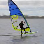
Now its time to get on the water, point your board far off the wind, clench your butt cheeks, sheet in and hold one.
Rest assured your GT-11 will be faithfully recording your every move, as one speedsailor I know often sats....once the data drops the bull**** stops!
The NAVi is a great little unit, treat it well and set it up correctly and you'll be rewarded with extremely accurate speed data.
Screw with it and change settings without any knowledge of their purpose and you'll end up with a jumbled mess!
Hey hardie, like lots of other sailors I am in the market for a gps suitable for speed sailing, even got myself some speed gear, but I'm confused about which gps I should purchase. From the GPS-speedsurfing site it sounds like the navi is still on trial and it all sounds very confusing to a layman like me, hate to buy one and find it is not allowed for gps speedsurfing. Do you know what the trial thing is all about and how its going in simple terms?
Jman,
I have no idea what firmware is.
The NAVi is suitable for this challenge here, and as far as I know GPSSS has approved it. The NAVi is supposed to be a very accurate GPS, but in order to get all info off it, software had to be designed to interpret it. Some problems have arisen in this process, but from what I hear, these have been resolved. Roo or others like Sailquik need to answer with a more technical response. I am a technical imbecile!!!
firmware....isn't that another term for a bra???
firmware is generally a software update that a manufacturer may post on their web site from time to time that can be downloaded by the user(usually for free) for subsequent uploading to the device(in this case the navi gps) it can be software that completely changes the function of the device or just a fix for a bug that was within the unit when originally shipped.
the navi unit has seen several firmware upgrades in the last month or so that has turned a (IMO) good gps into a great gps!!
most of these improvements have come about from rider(windsurfer) input, and mostly through Roo's dedication and commitment to the unit.
Hi Jman,
The navi is accepted for posts on GPS-SS on a trial basis. In fact, I believe it is very close to being fully approved. I would not worry about that too much. Many of the most enthusiastic speed sailors have already got them and are very pleased with them.
Here are the main reasons the Navi is considered better than the Foretrex/Geko for our purposes:
1. It is more accurate: The Foretrex/Geko do not save the full precision of the trackpoints to memory, probably a strategey by Garmin to save memory space. This means that when the trackpoints are plotted they have less precision and effectively fall on approximately a 2.4m grid. This means the the track takes on a zig-zag appearance when plotted and decreases accuracy as a consequence.
Another consequence of this is that we need to use these units on a 2 second setting to try to dampen down the worst of this grid effect, hence to 2 second rule for these on GPS-SS (and the Seabreeze Speed Teams Challenge)
The Navi GT-11 gps saves trackpoints in NMEA format which has a lot more precision.It is not quite as good as the unit is theoretically capable of but the maths experts seem to think it is more like a 20cm grid, 10 times better! Some other GPS's, notably the Garmin Edge are reported to be able to save to memory (trackpoints only) the full precision down to a few cm, but there is another big advantage in being able to use the NMEA data from the NAVI.
2. The Navi GT-11 saves NMEA data: This is a standardised gps output format that includes data about the numbers and positions of the satellites it is using, the calculated degree of precision (HDOP = Horizonal Dilution of Precision), and the doppler speeds (Speeds calculated as you are moving by using doppler shift from the raw satellite signal). There are other things as well but these are the most useful to us. The big advantage of this is that we can use this data to confirm the level of reliability of the trackpoint data. This very important thing cannot be done with trackpoint data alone that most other comsumer GPS's are set up to save. Say we go out and have a blindingly good run in the gust of the day. We may come back and show our mates the result and be greeted with a degree of scepticism. They might say,"it must be an error or a spike". With a normal GPS we would be struggling to argue against this, but with NMEA data we can have confirmation that it was indeed no error, or proof that it was in error and we can throw it out.
3. One second trackpoints: Because of the much higher degree of precision we can use the one second trackpoint setting. This means that the software can pick the very best bit of our speed track to the second, rather than the closest 2 seconds. eg: On a fast 100m run we often do 100m in 5 seconds. The Foretrex result has to be over 6 seconds and is often lower as a result.
4. A very large memory capacity: The GT-11 can save NMEA data to an SD card. If a whole days sailing only uses 10mb or less of capacity and we have a 512MB card, you can see that you would not have to worry about running out of space too soon and could save data from multiple sessions on a long holiday without having to download to a computer.
5. Ease and speed of download: No mucking around trying to get serial to USB adaptors to work. Simply pop the card out of the unit, insert in the card reader slot of your computer, PDA or a usb reader and copy and paste to your save data folder. A full capacity download from the Foretrex via USB to serial adaptor takes around 9 minutes. A 4 hour session from the SD card via a USB reader copies accross in around 5 seconds!
6. The Navi GT-11 GPS is significantly cheaper!
I hope this helps put things in perspective a bit.
Just discovered something cool:
The unit outputs NMEA data continuously at 4800 bps, 8N1 via the internal USB->Serial connection.
Just connect to the unit and watch the data scrolling... You could probably connect a GPS program to this and watch where you take your laptop.
Hey Nebbian! Great work to get the Mac connected via the serial interface!!!
Actually, the Foretrex will output NMEA data directly to a computer as well and I believe many other GPS will do the same. Unfortunately, the Garmins and the others won't save to memory in that format. Its a pity because the precision put out in NMEA data from the foretrex in real time is much more accurate than the stuff it saves to the memory.
Nebbs I can see you have been spending too much time with your NAVi seeing what it can do. There are many things it is capable of and that is one of the great things about the unit, we haven't started to take advantage of everything it has to offer.
If you really want to understand it more try this program from SiRF, the company that makes the GPS chip it uses. http://www.sirf.com/free_demo.html
Also thanks are due to you for stepping up to build and provide the website to run the team challenge. It's great to see a homegrown initiative catering to Aussie speedsailors needs.
Roo
Thanks Sailquik for the info on the Navi, looking forward to the purchase of one now.
Regards Jman
Jman, good to see you coming over to the dark side. Make sure you get an Aquapac for your NAVi GT-11, like the Foretrex they aren't totally waterproof. Also check the Firmware version when you get it, Version 1.5 0403 is the latest official release that has been thoroughly tested and works great for our speedsailing needs.
Roo