Yesterday I trekked in to the Henty River Mouth! Was at Strahan for work and before I headed back, I was determined to see how far the Henty River had carved down the beach. I had Google Earth images in hand and managed to finally find the only track in through the impenatrable vegetation. Ended up doing over 7 km of walking through sand, bogs and bush and had to use my GPS to find my way back out and back to the car!!
Probably shouldn't be posting all of this, but this is what I found!!
This is where the track came out at the beach - right at the mouth of the River!! Couldn't believe it and, as much as I had hoped, really didn't expect that the river would have pushed down this far:

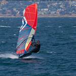
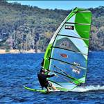
Looking right, this is what I saw!! This is all new, virgin speed strip, right up to where the sand angles back in toward the dunes. This new bit is just over 1.3 km long (GPS verified) and really does look very good:

Further up (camera zoom on full) is the original run where we usually sail, which is now 1 km in length (not that we'd ever actually had it looking this good)!!:

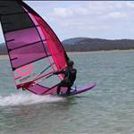
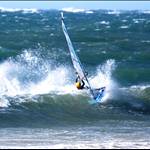
This is looking back down the new bit of the run:

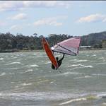
And this is looking at the end of the run where it turns out to sea:

Who knows how much further this run is going to cut through the sand? Maybe not much more now the winter rains have finished. Pretty incredible that when we first sailed this spot last year (still only been 5 times) we were sailing along a short 200-300m section. Every sailing session so far has produced multiple 40 knot runs, but we still haven't had a really good session (enough wind).
Anyway, the two sections each have their own nice arc, but together produce a straight line 2.3 km run!!
There are a few of us now who are watching the weather forecasts with a little more interest!!
It'll be a long walk back up, but the sand is hard and I don't reckon anyone will be too fussed if they've had a nice run ... ![]()
PS the trek in took so much effort, cause I thought it would be easier walking in the 2km from an old forestry track than do the full 4WD trek in and then still have to walk around 2km to get to the river mouth. However, I went down so many dead ends ... ![]()
This photo gives some idea of the terrain I had to navigate through, which you really could easily get lost in ...

And finally back to the car and able to say "mission accomplished":

![]()
this spot beats sandy point for running up along the sand,you can go the whole way with the rail on the bank haha and the fin still 1.5m plus not touching.it is just a dead straight drop off the bank.
p.s dave ya should of left this post till we got a go on it.![]()
dont want any intruders![]()
That looks bloody good Dave ![]()
![]()
![]() Some of the Pit Crew may find their way over there soon. Still doesn,t beat the Pit Izaak, the Pit is only 40mins away with no snow.
Some of the Pit Crew may find their way over there soon. Still doesn,t beat the Pit Izaak, the Pit is only 40mins away with no snow. ![]() Here,s hoping it works for you soon.
Here,s hoping it works for you soon.
Yep, that looks amazing Dave. Thanks for the great photos. I wonder how long until the river busts out near the top of the run?
Have any of you sailed it yet in a SW wind - ie port tack?
I know Izaak, but I couldn't resist!! I'm pretty sure we'll still be the first to sail it all the way to the end and hopefully our time will come soon!!
No, still haven't sailed it in a SW, Pete. This would probably be the best direction for a NM I reckon, but for speed I reckon WNW still.
This river changes quickly, as we've seen, and a prolonged dry spell and it will stop flowing and then when we next get rain it will burst out somewhere along it's length, which is pretty much how we found it 18 months ago.
Hopefully we'll make the most of it while it is like this!!
Hey Pete, if you come down with a contingent from VIC, you'll need to bring lots of muffins!! I'm sure they'd go down a treat while shivering in the cold snow waiting for the wind!!
Looks awesome Dave, very keen to go there. Let's hope a big cold front arrives soon.
No it's not easy to fly into either unless you have the appropriate visas![]()
![]()
Did you take a rod in? Looks like a sea-runner rising in the 4th photo.
Hope to be doing a bit of work over that way after new year, will have gear in van at all times. (plus a rod).![]()
Yeah
In 5 days there, my 2 mates from Croatia, broke like 5 booms
and last day, photo I linked and you put here noone is on the watter
The day before some German got into watter with sail 3.3, but wind
is broke him in less than 5 min
Hmmm, that's no good with the broken gear and off-shore winds!! Good thing about Henty is you can use your smallest gear and go out in the strongest winds (if we ever get them) and the worst (well, hopefully) that can happen is you end up on the opposite shore, 30-50m away!!
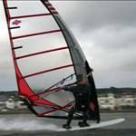
Another photo:

Please excuse the commentary, but here is the video version of my first view of the 'new' henty river mouth!!