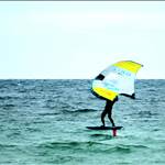
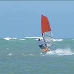
Best seabreeze of summer on Tuesday (the day I go back to work). The morning was still and cloudy, but the cloud burnt off late morning and the seabreeze started building about midday. By 2pm it was cranking. Quite often in Melbourne, it starts building about the same time, but never quite get there. This left me wondering if the morning cloud had any impact on the afternoon seabreeze.
Any advice on this?
Great question. The wind is part of the weather system so my thoughts are that they are all interrelated. The cloud also determines how much sun warms the land mass during the morning, thus influencing the land/sea temperature differential that kicks in an afternoon sea breeze. That's all I know about it though, and I am not a meteorologist. I have been observing different types of clouds ( high, medium and low level) and the wind patterns associated with them. Some cloud types really do seem to suppress the wind. I am not a fanatic about these things, however it is a better option than relying upon what the forecasters say. My gut feeling is that their wind forecasts are for higher altitudes, and not down at sea level where all sorts of landmass and obstructions play havoc with direction and strength.
the question seems to be related to cloud cover on a SUNNY day
if it is stormy with cloud and wind, the cloud is part of the equation
when on the water, I have heard fellow windsurfers say the wind will pick up again once that cloud passes
and I have seen it happen
is it a REAL fact or not = NO idea
generally cloud shuts down summer sea breezes here. It can be hot and sunny all day with increasing wind, then when I get a chance in the late afternoon the cloud cover has rolled in and it gets flakey. Sometimes it's best to go earlier.
clouds kill wind %99 of the time though an e wind in vic it can be hazy and still crank
a proper melbourne sea breeze 25knts+ is when the centre of the high is over melbourne….the more north the centre the High is to melbourne the stronger the sea breeze will be;) and the good sea breezes start out in the ocean then continue through the bay:)
Interesting and insightful question.
I favor the wind on the coast of central California much better than the wind on Maui, and it's all because of those big cumis (cumulus and cumulonimbus) clouds that always drift by on Maui. Those are wind killers, so it's often up and down, whereas in Cal., we rarely have those, so when it's windy it stays windy, much more uniform wind conditions.
Most everything else on Maui can be better tho, like water temp and the abundance of female skin.
I think Hawaii is the exception to the rule, because it's seems to get cloudy and rain off and on and there is still wind.
I live up in the mountains in Southern Oregon and we get clouds that can roll in fast, and the wind maybe good until the clouds roll in. But as soon as it gets 85-100% cloudy all bets are off. Wind will always become shifty, gusty or die off. Party sunny to all sunny days are the best.
Another strange thing is the wind only comes up in the late afternoon here about 4-5 pm and cranks until 10pm The lake is glass until then. Once the mountain peeks in the morning loose their sun from the morning hours, all that hot air that went up comes down in a north westerly fashion and brings us our wind. It's like clock work. But this only happens in the spring and summer. Fall and winter is another story.
Only talking about seabreezes in Port Philip Bay, and from observation,(staring out the office window for several decades) rather than meteorological qualifications. (Edit: plus a science degree according to the document on the wall)
Cloud early in the morning doesn't seem to adversely affect the seabreeze. As long as the cloud burns off, and the sun has a good chance to cook up interior land. But if the cloud persists until midday inland (50-100kms inland) the seabreeze is likely to be crap. If the air over land is drier, rather than humid, the seabreeze should be stronger. Melb temp was not high, low 20's max, Coldstream was 13 degrees early, then up to 23, so a fair temp change. Shepparton was up to 29 with low humidity.
If the seabreeze hasn't switched on by about 3-3:30pm, it probably won't happen, except sometimes for more isolated brief bayside seabreezes. If there's an underlying light southerly airstream in the morning it will help turbo-charge the seabreeze- if it's northerly during the morning or midday, if there's any seabreeze it's likely to be crap. Last Tuesday was the classic pattern. Light southish (SE) background, switch-on at around 3:30, and cranking and consistent until sunset.
Don't worry- we both missed it.
Have a look at this from the Bureau on NSW seabreeezes- same principles http://www.bom.gov.au/nsw/amfs/Sea-Breeze.shtml
My theory (based loosely on year 9 science![]() )
)
Seabreeze is caused by the hot air rising off the heated land, which draws in the cooler air off the ocean. Put cloud cover in the way of the heat and you get a two way insulating layer.
no heat on the land =less/no breeze
cooler layer(cloud) in the way of hot rising air = less/no breeze.
I could be completely wrong.
Select to expand quoteSubsonic said..
My theory (based loosely on year 9 science ![]() )
)
Seabreeze is caused by the hot air rising off the heated land, which draws in the cooler air off the ocean. Put cloud cover in the way of the heat and you get a two way insulating layer.
no heat on the land =less/no breeze
cooler layer(cloud) in the way of hot rising air = less/no breeze.
I could be completely wrong.
Yeah - I think that makes sense, but why then can you have a lovely 32 degree day and a piddly seabreeze? Or a hot 40 degree day and no seabreeze? My original question related to cloud was more about could cloud cover that burnt off make for a better seabreeze. We had a day earlier in the week where there was no wind and cloud cover until about midday. It was warm, but warmed up to high 20s once the cloud burnt off and it was a banging 25 knot seabreeze in the arvo. Did the cloud do this, or was it something else? Like a pressure system perhaps?
Select to expand quoteSputnik11 said..
Best seabreeze of summer on Tuesday (the day I go back to work). The morning was still and cloudy, but the cloud burnt off late morning and the seabreeze started building about midday. By 2pm it was cranking. Quite often in Melbourne, it starts building about the same time, but never quite get there. This left me wondering if the morning cloud had any impact on the afternoon seabreeze.
Any advice on this?
Not a meteorologist... But you need a stable atmosphere for a decent seabreeze to develop. By stable I mean the atmospheric lapse rate, i.e. the rate of temperature decrease with altitude needs to be such that when a parcel of air is lifted it will be COOLER than the surrounding air, so it will descend again whence it came. It is slightly more complex than this because the lapse rate for saturated (a cloud) versus unsaturated is different, 1.5celsius instead 3 per 1000ft.
One purpose of weather balloons is to measure this stuff, and with some simple maths, cloud heights and types can be predicted. Probably all done on a big computer now, but it can be done this way. ![]()
A high represents stable air (it is cooler descending air), it will suppress the development of large cumulus and thunderstorms. It won't overcome local areas of unstable air, such as near a front. A trough/low is the opposite and will encourage such clouds.
You can apply all of this in reverse. i.e. look at the type of clouds and their vertical development to work out if an airmass is stable or not. Your example sounds like a layer of stratus clouds (stable air), which burnt off after lunch, the stable air stopped the development of large cumulus clouds. This is the practical aspect for a windsurfer, an alternative to the synoptic chart.
Why the stable air? Stable air stops layers of air from mixing, keeping the seabreaze local to that layer, and accelerating it.
Sorry for the lecture ![]() , no seabreeze for me at moment
, no seabreeze for me at moment ![]() As with many things in life I am sure there is more to it than this, but a few things to consider.
As with many things in life I am sure there is more to it than this, but a few things to consider.
I suspect the cloud does two things, particularly when it comes to seabreezes (as opposed to fronts and the like)
1) as stated above- large volumes of clouds stop the warning rays of the sun heating the land. With no cloud the suns causes the air heat, expand, become less dense and hence rise and draw in the sea breeze (creating lower pressure over the land).
2) (and this probably depends a bit on topography) the cloud acts like a barrier or "plug" to the breeze pushing through. When I sailed for many years in Wollongong, (where there is a big continuous escarpment 300-500m altitude behind the coast) it seemed to be the case that if the cloud hung on the escarpment, the seabreeze struggled to kick in.
The second probably also relates to RacerX's comment about lapse rates, temperature inversions and so on too- but I'd have to do a bit more homework before I could say much more than than.
One local sailor (RIP George) had an interesting theory about the far inland lakes such as Lake Eyre. The theory went something like that when the lakes were dry, all the pelicans came to the coast (rather than inland lakes). In these years a more intense low pressure could be generated over the inland, and hence seabreezes were more intense. His theory was that in summers when there were more peclians on the coast (because the inland lakes were dry), the seabreezes were more consistent. Interesting idea.
Clarence
Cloud is a word used to describe a number of different formations in the atmosphere. It is crucial to identify the type and what level it is at because they are related to the air movements in the atmosphere in different ways. There are also up drafts and down drafts alongside cumulus clouds. Stratus cloud often brings rain or fog and with little wind. Frontal cloud formations signal something else.
When there's a classic sea breeze in Perth, you get let some balloons go and they will blow inland, wait 30 minutes and you will see them up higher and heading out to sea. The seabreeze is very will defined. I've sailed out past the seabreeze into no wind at all, I could see my mates a few hundred betres from the beach getting jumps while I was swimming back into the zone.
Select to expand quoteAgrid said..
When there's a classic sea breeze in Perth, you get let some balloons go and they will blow inland, wait 30 minutes and you will see them up higher and heading out to sea. The seabreeze is very will defined. I've sailed out past the seabreeze into no wind at all, I could see my mates a few hundred betres from the beach getting jumps while I was swimming back into the zone.
With an unstable lapse rate/atmosphere, warmer air will tend to keep rising and form clouds with more vertical development, more so over land, all this mixing between layers inhibits the scenario Agrid describes. If the balloon finds its way into a large cumulus cloud while over land its up, up, an away. Select to expand quoteclarence said...
2) (and this probably depends a bit on topography) the cloud acts like a barrier or "plug" to the breeze pushing through. When I sailed for many years in Wollongong, (where there is a big continuous escarpment 300-500m altitude behind the coast) it seemed to be the case that if the cloud hung on the escarpment, the seabreeze struggled to kick in.
That's a tricky one, my guess is the stratus clouds created by ridge lift (orographic), may act as a large sun shade, or perhaps its too small to have an effect and it's just a marker with regard to larger unseen atmospheric conditions that are limiting the breeze, i.e. a speedometer of sorts.
Other than just uneven heating of sea and land, other things that will have an effect are both the direction and strength of the gradient wind, and the direction with respect to the coastline. As the Coriolis force veers and backs the wind as its speed changes and the gradient wind interacts, the net result is sail sizes will need to change.
Be interesting to hear from a met forecaster, not sure if I would trust them though ![]()
It's -20 here today ![]()
Display solar heating panels all over the place. Turn them on at dawn and shut them off at 11am. About 1-2 hours later there will be wind. Wind every day. The heat of the sun in combination the solar heat being produced would be phenomenal. Boy if I had my own lake with lots of acres, I would experiment with that. If it was a success I would name it, " Winds Lake". Welcome to all windsurfers. Wind every day except when it rains.
Warning: Kiters turn back, do not enter. Windsurfing territory only. If any kites are rigged, kiters will be sited and told to leave by the authorities hired by "Winds Lake".
Was overcast again today, but pretty much all day. And it had me thinking again. Give me a bit of latitude here.
I was cooking roast potatoes on the weekend. They turned out really well. Crispy and golden on the outside. Soft and fluffy in the middle. Perfect after a massive session on the best day of summer so far on Sunday. I was happy.
Anyway, I opened the oven to turn the potatoes over (as you do if you want the crispy effect) and I was hit with a hot gush of steamy hot air. It lasted for a second or so and then back off. I thought of the cloud effect. Maybe clouds do this. Maybe they trap the heat as it builds in the morning and when they burn off quickly, the hot air gushes up. More than it normally does. Accelerating the seabreeze effect.
Morning cloud. Heat build up. Nowhere for hot air to go. Clouds burn off. Hot air rises in a blast. Seabreeze kicks in with greater than usual gusto.
Plausible?
I'm only guessing but I think the seabreeze is well below the altitude for cloud formation.
Select to expand quoteAgrid said..
I'm only guessing but I think the seabreeze is well below the altitude for cloud formation.
But others have said cloud would kill a seabreeze?
OK, let's go with the "hood barbeque" model of seabreezes. Remember, the engine room of a seabreeze is inland, so let's pretend the barbie is somewhere inland. In the barbie we have a heat source (flame) that cooks up the air under the hood to a temperature significantly above outside air temp. Let's use a candle outside the barbie as a wind speed and direction indicator. Hold the candle outside the hood at hotplate level.
When you lift the lid, and get hit in the head with a gush of hot air (heated air being less dense than the ambient air, so it is displaced upwards) you should notice that the flame of the candle is drawn in the direction of the barbie. That's your backyard barbie seabreeze, as cooler air rushes in to displace the bubble of hot air that has just singed your eyebrows. Go get you Lego windsurfer dude and watch him have a 2 second blast in the speed strip you've set up just next to the barbie.
So, what's the deal with the clouds? The sorts of clouds that are formed by the barbie hot air bubble are the cotton wool fluffy cumulous, or the mega cotton wool factory with the anvil flat top cumulonimbus clouds. They are formed by the updrafts of air heated in the barbie rising up into cooler air as they progress away from the barbie. There will be some moisture in the hot air, which has been driven out of your now perfectly crisping spuds. When that moist hot air cools to a temperature called the dew point, the moisture condenses, and the cloud will appear. As the moist condensing air continues to climb, the fluffiness builds until it runs out of heat at the top of the cloud.
The clouds build in lots of barbies inland, and so there's many bubbles of hot air rising. The best bubbles form over barbies on dark soil, because, like your suggestion to "paint it black" that will absorb and transfer more heat from the sun and cook up the adjacent air. Green fields are crap barbies. The cumulous clouds are indicators of where the best thermal activity is happening, so if you want good potatoes, drive to a place underneath the biggest fluffiest clouds.
Now these clouds are created by the barbie's thermal activity and you don't want baked potatoes first thing in the morning. To get your potatoes crisp inland, you have to get the barbie hot, hot, hot, so you only fire the barbie up late morning or afternoon. If you try to cook your spuds slowly at a low temperature, they'll be crap. If you have lots of cloud cover in the morning that stops you from getting the barbie hot when you want to cook , i.e. the barbie never gets hot under the hood, when you lift the hood you won't get that eye-scorching blast in the face. No hot air will be shooting skywards, and the little wind indicator candle will hardly flutter when you lift the hood. No seabreeze.
Remember, the seabreeze barbie engine room is inland, not on the deck of your bayside abode. So when you look out your bayside window and see a blanket of grey and think, "Bugger, no topless sunbathing for the neighbours today", fear not, your inland seabreeze barbie, under clear Australian skies, will be cranking by lunchtime, and by the time you get to lift the hood to turn your perfectly crisping spuds, the hot air build up will be ready to explode like the nuke tests at Maralinga, and windsurfers around the Bay will rejoice.
Now, does pork crackling come with that?
Select to expand quoteSputnik11 said..
Maybe clouds do this. Maybe they trap the heat as it builds in the morning and when they burn off quickly, the hot air gushes up. More than it normally does. Accelerating the seabreeze effect.
Morning cloud. Heat build up. Nowhere for hot air to go. Clouds burn off. Hot air rises in a blast. Seabreeze kicks in with greater than usual gusto.
Plausible?
Yes, clouds release heat as water vapour condenses, this changes the lapse rate so that a given parcel of air will be warmer than it would be otherwise be and will thus continue to rise, this is a big factor in the creation of a thunderstorm (they probably would not exist otherwise), but this is not good for a sea breeze.
Its not all about heat, or heat differential even though it is an essential ingredient, plenty of really hot places near the sea with no breeze, take Perth when a trough moves nearby during summer.
I have also read that when a large body of water starts to heat up due to the outside temps rising into the summer seasons, the warmer water can have an affect on the wind as well, by actually reducing the wind velocity. Don't know if this is as effective for ocean waters or not, But I am becoming a believer that this occurrence is true where I live at my lake. Klamath Lake where I live is 22 miles long, 2-3 miles wide and between 15-30 feet deep. After the lake thaws from winter snow, the water will range from 33 degrees up to 72 degrees by July. Wind is good until July, then by August the north westerly winds shut off, even though the air temps are in the upper 90s, the lake is warm, the air is warm and there is no wind. We may get like a 5 Knott north west breeze, but not the usual 10-20 NW breeze. We will also start getting some SW and east breezes around August through the winter, but it seems that from April-July are the best times for consistent NW winds. Strangest thing. I have been here for 7 years now and every year repeats itself. The lake seems to thaw a little early ever year, allowing the north westerly winds to start early in the year. I can usually start sailing the end of February or early March, catching some NW, SW and some east winds. It gets me all tuned up for the NW winds that begin in April.
Melbourne.
10th January.
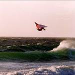
Another day of mid 20s, more low level morning cloud that burnt off late morning. Another banging seabreeze by mid afternoon.
Although, maybe the common denominator is that it was a Tuesday....
Select to expand quoteSputnik11 said..
Melbourne.
10th January.
Another day of mid 20s, more low level morning cloud that burnt off late morning. Another banging seabreeze by mid afternoon.
Although, maybe the common denominator is that it was a Tuesday....
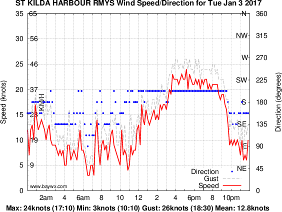
I found the aerological chart for melbourne on the 10th. (weather balloon)

The red lines are a temp traces taken around 10pm tuesday, the blue ones are 10am in morning. The two lines on the left are the respective dew points for the two balloons, the two lines on the right are temps for the two balloons.
There was a strong inversion starting about 2500ft, the atmosphere was pretty stable (the temp lines stay to the right of the grey slopping line in the middle). Probably was a good day for a seabreeze...
Looking at the previous day, a layer of stratus clouds would probably have formed with a base of 2000ft, be gone around 10am.
These are all actual observations, not forecasts.
Select to expand quoteracerX said..Sputnik11 said..
Melbourne.
10th January.
Another day of mid 20s, more low level morning cloud that burnt off late morning. Another banging seabreeze by mid afternoon.
Although, maybe the common denominator is that it was a Tuesday....
I found the aerological chart for melbourne on the 10th. (weather balloon)
The red lines are a temp traces taken around 10pm tuesday, the blue ones are 10am in morning. The two lines on the left are the respective dew points for the two balloons, the two lines on the right are temps for the two balloons.
There was a strong inversion starting about 2500ft, the atmosphere was pretty stable (the temp lines stay to the right of the grey slopping line in the middle). Probably was a good day for a seabreeze...
Looking at the previous day, a layer of stratus clouds would probably have formed with a base of 2000ft, be gone around 10am.
These are all actual observations, not forecasts.
Thanks Racer. For those of us a little meteoroligcally challenged, could you dumb it down. What does this mean?
On a related topic, does anyone know why, when the BOM forecasts several days of strong seabreezes in a row, there will always be at least one that doesn't blow, despite that day looking equally good on the synoptic chart etc. They tend to start picking up like a good one, then not get past ten knots.