I'm heading up Noosaville way in a few weeks and will have access to a Prado 4x4... anyone have any tips about travelling to/surfing at Double Island Point? Was thinking of hiring a SUP while up there as a chance to try out some new surf gear. Would be mid-week. Worth it?
Does Jack Newton swim in circles? any trip to DI is bloody worth it!
PS don't tell anyone![]()
There has been alot of erosion so just make sure you time the tides right , some parts are impossible at high tide with no escape and your car will end up like a crushed Coke can if you can't back out ![]() you also need a permit and the ranger is a pr!ck.
you also need a permit and the ranger is a pr!ck.
Head through Gympie and Freshwater Track to the beach south of DI ,that will cut out a lot of coffee rock.
Piros is right the beach is very knocked around. Normally travel is possible One hour either side of high tide. At the moment the travel is reduced to around an hour to an hour and a half either side of low tide. There are exposed rocks at Teewah and the top side of DI is a bit dicky. Don't even think about driving west to Rainbow. You need an access permit which you can buy at the Ranger Station at the North Shore ferry.
The safest option, if you are inexperienced, is as PTSup says.
Sorry Piros the rangers are just doing their job which is made difficult sometimes.
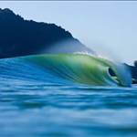
If you get it right the outside at the point has been working and there are a range of banks along the lagoon.
Have fun!
ET.![]()
Yeah sorry that was a bit syndical ![]() If you do the day raid and you see the ranger go to this site on your phone and download a permit. I copped a $200 fine on this shoot .Here's a video I did 2011 of our trip to DI. Small waves but the place is just great.The beach is nothing like this now , coffee rock is really exposed everywhere. The shoot starts at the ferry from Noosa you need to ask which cutting to the beach you go down on.Bit of a local scene their so just be nice and share the stoke.
If you do the day raid and you see the ranger go to this site on your phone and download a permit. I copped a $200 fine on this shoot .Here's a video I did 2011 of our trip to DI. Small waves but the place is just great.The beach is nothing like this now , coffee rock is really exposed everywhere. The shoot starts at the ferry from Noosa you need to ask which cutting to the beach you go down on.Bit of a local scene their so just be nice and share the stoke.http://parks.nprsr.qld.gov.au/permits/faces/publichome.jspx?_afrLoop=12558619267210657&_afrWindowMode=0&_adf.ctrl-state=7enh8quvh_134

You can only use the second cutting to go north to DI. First cutting is south only towards the Noosa river mouth. The area in between is now closed and is for use by pedestrians only. This was done to make it safe for kids on the beach in front of the campground.
By the way Piros I like your car. I am a Landy man too.![]()
ET.
Yes AA it was a great trip on the old trusty PSH's.
I do recall someone knee paddling with one arm that day![]()
All good down your way?
This info is gold guys... many thanks.
I'm champing at the bit to get there now.
Good waves to you all...![]()
Select to expand quotewazza66 said..
Yes AA it was a great trip on the old trusty PSH's.
I do recall someone knee paddling with one arm that day![]()
All good down your way?
Yeah back to two working arms and two working legs and loving the surf SUP!
Took the family back after that little trip Wazza. Had a ball. Everything was drivable (just).
Spooked the family big time after visiting the Rainbow Beach hotel and seeing the 4WD trophy wall![]()

Hope all is well on the Goldy and you have another trusty under your feet!
Are cars safe when the tide comes in at the point camp site.?.....And could I get my Kombi there.?
Select to expand quotePiros said..
Yeah just make sure you check the tides
wonder why the place has serious erosion issues
Hey MacRab, you can't camp at the point and haven't been able to for a long time. The closest place to camp is the Freshwater campground which is a couple of kilometres back. National Park controlled and all you need. You have to book though. Otherwise you camp on the eastern beach or north shore beach north of Teewah to just south of Freshwater. The areas are signposted. You need a camping permit and a vehicle access permit which you can get via the Internet or at the Ranger office near the north shore ferry. If you are an experienced Kombi driver you may be OK. I hav e regularly seen Kombis on the beach and even saw a group of Kombi's and Buggies up on Fraser Island. The areas to watch are, the beach accesses and exits as they get very churned up and can be soft and fluffy. At the moment there are exposed rocks so the time of travel is important. Hope you have fun.
ET.![]()
Select to expand quoteTractorguy said..Piros said..
Yeah just make sure you check the tides
wonder why the place has serious erosion issues
I guess you are referring to the many trees that have died at DIP in the last few years that have allowed dune slip and other changes not seen for a while......
Yeh Mate , hate to be a downer but, been comin here ^^^^ For a lot of years , have not seen the degredation of sand hills so bad as in last year we visited ( 2012).
But this is not just common for the sth east QLD coast , its prevalant from cairns to NTH NSW, saw the massive dunes at Agnes waters to 1770 couple of years ago reduced dramatically , lately , videos of indo / ments show the same thing,dead trees and reduced beach , not sure of an explanation maybe global warming eh ?
My local has lost a hunderd meters of beach dunes in the last 3 years.![]()
Select to expand quoteTractorguy said..
Yeh Mate , hate to be a downer but, been comin here ^^^^ For a lot of years , have not seen the degredation of sand hills so bad as in last year we visited ( 2012).
But this is not just common for the sth east QLD coast , its prevalant from cairns to NTH NSW, saw the massive dunes at Agnes waters to 1770 couple of years ago reduced dramatically , lately , videos of indo / ments show the same thing,dead trees and reduced beach , not sure of an explanation maybe global warming eh ?
My local has lost a hunderd meters of beach dunes in the last 3 years.![]()
I think the Indo thing, islands off Sumatra is a tectonic plate thing - could be wrong, but they've been sliding under since before I went there years ago.
Select to expand quoteTractorguy said..
Yeh Mate , hate to be a downer but, been comin here ^^^^ For a lot of years , have not seen the degredation of sand hills so bad as in last year we visited ( 2012).
But this is not just common for the sth east QLD coast , its prevalant from cairns to NTH NSW, saw the massive dunes at Agnes waters to 1770 couple of years ago reduced dramatically , lately , videos of indo / ments show the same thing,dead trees and reduced beach , not sure of an explanation maybe global warming eh ?
My local has lost a hunderd meters of beach dunes in the last 3 years.![]()
First off, its climate change, not global warming.....that term went out a few years ago now, but the nay sayers love to hang on to it. There are alot of variables, one of the main one is wave frequency. Above a certain frequency sand is erroded, below it si deposited. Frequency is not size of wave. Now im sure you are aware that over the last 5 years or so we have not had many cyclones, but some good low pressure systems that have brought waves with them. Brisbane has had its fair share of flooding over these years, brought about by the lows that also bring the waves....
again, alot of variables......
Select to expand quotehusq2100 said..Tractorguy said..
Yeh Mate , hate to be a downer but, been comin here ^^^^ For a lot of years , have not seen the degredation of sand hills so bad as in last year we visited ( 2012).
But this is not just common for the sth east QLD coast , its prevalant from cairns to NTH NSW, saw the massive dunes at Agnes waters to 1770 couple of years ago reduced dramatically , lately , videos of indo / ments show the same thing,dead trees and reduced beach , not sure of an explanation maybe global warming eh ?
My local has lost a hunderd meters of beach dunes in the last 3 years.![]()
Now im sure you are aware that over the last 5 years or so we have not had many cyclones,
.....
What do you call call yasi in 2011,im glad we don't get cat 5s every year.
Select to expand quoteweiry said..husq2100 said..Tractorguy said..
Yeh Mate , hate to be a downer but, been comin here ^^^^ For a lot of years , have not seen the degredation of sand hills so bad as in last year we visited ( 2012).
But this is not just common for the sth east QLD coast , its prevalant from cairns to NTH NSW, saw the massive dunes at Agnes waters to 1770 couple of years ago reduced dramatically , lately , videos of indo / ments show the same thing,dead trees and reduced beach , not sure of an explanation maybe global warming eh ?
My local has lost a hunderd meters of beach dunes in the last 3 years.![]()
Now im sure you are aware that over the last 5 years or so we have not had many cyclones,
.....
What do you call call yasi in 2011,im glad we don't get cat 5s every year.
define "many".......
Select to expand quotehusq2100 said..weiry said..husq2100 said..Tractorguy said..
Yeh Mate , hate to be a downer but, been comin here ^^^^ For a lot of years , have not seen the degredation of sand hills so bad as in last year we visited ( 2012).
But this is not just common for the sth east QLD coast , its prevalant from cairns to NTH NSW, saw the massive dunes at Agnes waters to 1770 couple of years ago reduced dramatically , lately , videos of indo / ments show the same thing,dead trees and reduced beach , not sure of an explanation maybe global warming eh ?
My local has lost a hunderd meters of beach dunes in the last 3 years.![]()
Now im sure you are aware that over the last 5 years or so we have not had many cyclones,
.....
What do you call call yasi in 2011,im glad we don't get cat 5s every year.
define "many".......
well i can count two in qld last summer thats about average.
look at it any way you want. My point was that you dont need a cyclone to create the frequency of waves that will eriode beaches. I was simply stating, for those that may come and say, "but hang on, we havent had "many" cyclones". Which IMO is true, on the australian coast we have been below average. DIP has not slowly changed since the introduction of 4x4, nore has it changed over night from once major weather event, but if you do go there more than once a while, you will see what we may call large changes in short time. And if it was simply due to 4x4 then there would be no point at which it improved. Pics in the pubs will prove that as you can have all the coffee rock exposed at Rainbow and months later it totally covered again...