So everyone has become instant weather experts by dialling into the different services whether it be Meteye or any of the commercial sites but at the end of the day all the commercial sites operate on the BOM feed generally and it is just a different algorthym that makes pretty pictures on the screens.
Weatherzone can give access to models other the BOM model and other pay for view services use the NOAA model.
Those of us that watch these things closely everyday usually get to know the weakness of the model, for instance the NOAA model for SW Pacific usually overestimates the size and intensity of low in the Coral sea while no model deals with katabatic breeze on the central QLD coast.
So here is an object lesson in looking at the models.
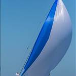
Early last week me, Cisco and Shaggy went to take the POGO north from Brisbane.
All BOM based models pointed to 20 -25 max from SE with isobars very evenly spaced over a good distance and nothing on any of the BOM charts to alarm you.
Forecast advised a ridge forming further north but again not a strong ridge.
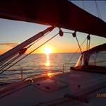
Ten hours into the trip off Double Island Point, the reality was 20s building to 35-45 and max close to 50 from the ENE by 2100hrs and this continued for about the next 8 hours with pressure going slowly back into the ESE but not dropping into the even into the high 20s for another 18 hours.
So not a real smacking but very different from the forecast particularly as to direction which turned a nice run into a tight reach in very confused seas.
The real issue here is the models even allowing for the 40% warning.
So after talking to a few experts and thinking about things the lessons where these.
There is a general view that the resolution of the BOM marine models has been downgraded (btw aviation has priority)
The resolution was not sufficient to identify the steepness of the ridge forming where it did.
Our track steering 010M for most of the night was straight along the front of ridge so it never passed over or away from us for many hours.
But none of that explains why the true wind direction was as far round as 065M and by the sea state it had been round there for some time by the time before we got to Breaksea Spit.
Just thought I would get this out there as everyone gets so reliant on the pic of the screen without understanding the limitations of the thing drawing the pretty pic.
Or maybe I just got it wrong!
BTW hope we going sailing together again Cisco, it was pleasure.
Might have to tempt you with some southern island cruising!
Select to expand quotelydia said..
So everyone has become instant weather experts by dialling into the different services whether it be Meteye or any of the commercial sites but at the end of the day all the commercial sites operate on the BOM feed generally and it is just a different algorthym that makes pretty pictures on the screens.
Weatherzone can give access to models other the BOM model and other pay for view services use the NOAA model.
Those of us that watch these things closely everyday usually get to know the weakness of the model, for instance the NOAA model for SW Pacific usually overestimates the size and intensity of low in the Coral sea while no model deals with katabatic breeze on the central QLD coast.
So here is an object lesson in looking at the models.
Early last week me, Cisco and Shaggy went to take the POGO north from Brisbane.
All BOM based models pointed to 20 -25 max from SE with isobars very evenly spaced over a good distance and nothing on any of the BOM charts to alarm you.
Forecast advised a ridge forming further north but again not a strong ridge.
Ten hours into the trip off Double Island Point, the reality was 20s building to 35-45 and max close to 50 from the ENE by 2100hrs and this continued for about the next 8 hours with pressure going slowly back into the ESE but not dropping into the even into the high 20s for another 18 hours.
So not a real smacking but very different from the forecast particularly as to direction which turned a nice run into a tight reach in very confused seas.
The real issue here is the models even allowing for the 40% warning.
So after talking to a few experts and thinking about things the lessons where these.
There is a general view that the resolution of the BOM marine models has been downgraded (btw aviation has priority)
The resolution was not sufficient to identify the steepness of the ridge forming where it did.
Our track steering 010M for most of the night was straight along the front of ridge so it never passed over or away from us for many hours.
But none of that explains why the true wind direction was as far round as 065M and by the sea state it had been round there for some time by the time before we got to Breaksea Spit.
Just thought I would get this out there as everyone gets so reliant on the pic of the screen without understanding the limitations of the thing drawing the pretty pic.
Or maybe I just got it wrong!
BTW hope we going sailing together again Cisco, it was pleasure.
Might have to tempt you with some southern island cruising!
But they can predict the weather in a 100 years!!
As an ex naval aviator and long time sailor, weather forecasts are for general guidance only.
If the forecast is for serious bad weather, accept it to stay at home. If you think the weather is marginal for you, the crew and yacht stay at home because it might be much worse. If you accept the forecast as suitable for your trip be prepared for worse weather and, if you can't run for cover, you must be prepared for anything.
That is the point, it is just guidance but that does not mean we should not act with precision and I am not complaining but trying to understand the limitations.
Thought others may learn from it.
I should also say that it is piece of water I have sailed over perhaps 50 or more times which why I am trying to get my head around things.
Select to expand quotelydia said..
So everyone has become instant weather experts by dialling into the different services whether it be Meteye or any of the commercial sites but at the end of the day all the commercial sites operate on the BOM feed generally and it is just a different algorthym that makes pretty pictures on the screens.
Weatherzone can give access to models other the BOM model and other pay for view services use the NOAA model.
Those of us that watch these things closely everyday usually get to know the weakness of the model, for instance the NOAA model for SW Pacific usually overestimates the size and intensity of low in the Coral sea while no model deals with katabatic breeze on the central QLD coast.
So here is an object lesson in looking at the models.
Early last week me, Cisco and Shaggy went to take the POGO north from Brisbane.
All BOM based models pointed to 20 -25 max from SE with isobars very evenly spaced over a good distance and nothing on any of the BOM charts to alarm you.
Forecast advised a ridge forming further north but again not a strong ridge.
Ten hours into the trip off Double Island Point, the reality was 20s building to 35-45 and max close to 50 from the ENE by 2100hrs and this continued for about the next 8 hours with pressure going slowly back into the ESE but not dropping into the even into the high 20s for another 18 hours.
So not a real smacking but very different from the forecast particularly as to direction which turned a nice run into a tight reach in very confused seas.
The real issue here is the models even allowing for the 40% warning.
So after talking to a few experts and thinking about things the lessons where these.
There is a general view that the resolution of the BOM marine models has been downgraded (btw aviation has priority)
The resolution was not sufficient to identify the steepness of the ridge forming where it did.
Our track steering 010M for most of the night was straight along the front of ridge so it never passed over or away from us for many hours.
But none of that explains why the true wind direction was as far round as 065M and by the sea state it had been round there for some time by the time before we got to Breaksea Spit.
Just thought I would get this out there as everyone gets so reliant on the pic of the screen without understanding the limitations of the thing drawing the pretty pic.
Or maybe I just got it wrong!
BTW hope we going sailing together again Cisco, it was pleasure.
Might have to tempt you with some southern island cruising!
It would be interesting to see the four day pressure map for that period .............
looked at that at the time and nothing special there but that would never have the resolution been 4 hpa gradient.
The really stupid thing is in Tasmania I always wear a barometer on my wrist as the pressure moves so much there and in QLD I left it as home because usually exscpet there is big low the pressure never moves that quickly.

There are plenty of other variables to look at apart from synoptic charts; currents, sea temp, water depth, air temp, humidity, dew point, land features, tides etc etc, all these can effect the weather in a local area/region. Pretty hard to accurately model weather and sea states with so many variables and sadly human input (local knowledge and experience) is now pretty much replaced by complete computer modelling.
Dont understand your comment on aviation priority? But aviation forecasts can also get it very wrong, as this serious incident will attest.
www.atsb.gov.au/publications/investigation_reports/2013/aair/ao-2013-100/
Hi
In this technical age we rely on others to tell us what lies ahead, NOAA is run by the yanks would you trust them !!!!
they are only a guide and yachties are at the end of the pecking order unless you pay for professional routing/predict wind .
Did you check the Barometer ,
The days before there would have been a sloppy sea swell
When you go to sea expect the unexpected , also there was a time frame to go north
and we all know when a time frame comes into delivering the weather isn't going to behave part of the way.
one thing i did learn recently is, where an isobar changes direction radically , ie 90 deg or 180 deg . the wind speed will increase enormously .
no matter whether its a high or low , same deal , big increase of wind at that location .
Select to expand quotelydia said..
BTW hope we going sailing together again Cisco, it was pleasure.
Might have to tempt you with some southern island cruising!
It was a pleasure sailing with you too Lydia. Your presence was missed on the remainder of the voyage. Upon my advice and confirmation by a phone call from Shaggy to somebody, we exited Gladstone via the passage between Curtis and Facing Islands on the tide and I believe saved many hours over going up the Narrows and probably many sand fly bites too. ![]()
You would have been impressed with how the Pogo handled the whale strike we had just south of Mackay. It got me out of bed in a nano second. ![]()
You said to us on the boat that BOM info is now mostly auto generated by unmanned instruments and recorded at higher atmospheric levels than is useful for us low flying yachties. No doubt you could expand on that for us lay type people. ![]()
Tempt me with southern island cruising?? I am always tempted by island cruising, it is just the word southern that concerns me. Summer and southern start with the same letter. More information please.
Great to hear from you again so soon. Cheers Cisco.
Select to expand quotespiggie said..
NOAA is run by the yanks would you trust them !!!!
That may be a tad unfair to say. The U.S. is probably the most technologically advanced country in the world.
Select to expand quotelydia said..
The really stupid thing is in Tasmania I always wear a barometer on my wrist as the pressure moves so much there and in QLD I left it as home because usually exscpet there is big low the pressure never moves that quickly.
So there is still a good reason to have a barometer on board a yacht? How long have barometers been around?
I remember in high school physics class being shown how to measure atmospheric pressure using a 30 inch glass tube filled with mercury with it's open end submerged in mercury which then progressed to how a bellows barometer worked.
Now we have wrist barometers!! How good is technology today!! Is there an app for smart phones that will measure barometric pressure??
here's a couple Cisco
apps.apple.com/au/app/barometer-altimeter-for-iphone/id923043780
www.androidweather.net/apps-barometer
I'm small, so when in QLD if the weather said 20 + knots I knew they really mean't 25 + so stayed where I was ![]()
phone apps don't give you real pressure readings....there is nothing on the phone that measures it.
It just gets the reading from the nearest weather station, which will be close in the city. But as you travel more distance it will get less accurate.
Select to expand quotenods said..
phone apps don't give you real pressure readings....there is nothing on the phone that measures it.
It just gets the reading from the nearest weather station, which will be close in the city. But as you travel more distance it will get less accurate.
Good point. We should all have the old style barometer along side the chart table.
Select to expand quoteFreeRadical said..
iPhone 6, iPad Air 2, Galaxy S7 - have barometric sensors.
I stand corrected...some of the latest phones do....