I have been out of sailing for near the last 30 years.
In the early 80s I built a steel 40ft monohull and cruised some of the Queensland coast and ventured offshore to NZ , Solomons ,PNG and a couple of other places.
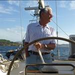
I'm now the owner of a shiny 10 meter catamaran with lots of bells and whisles that I purchased some 5 months ago. I have been Messiing about between the Gold Coast and Pancake Creek and am currently heading back south.
I have found myself musing over the differences between the 80s and now for cruising and thought I might share some of them with you.
NAVIGATION/ ELECTRONICS
Well the changes are amazing , I used to have a hand bearing compass , charts and when I went off shore for the first time , a sextant along with an NC77 calculator, much easier than sight reduction tables . Sat Nav (the forerunner to GPS ) was available but very expensive so was out of the question. The shiny boat has a chart plotter - it's better than sliced bread. Try turning yours off for a couple of days an you will really appreciate what it does.I read recently on this forum an article on the pros and cons of wind instruments and wether to repair them. The shiny boat has wind instruments, the old boat had a wind indicator mast head , I used to have cars were the window winder was the air con button, now if the air conditioning breaks down I would get it repaired , much more comfrtable than driving with the windows down.
MARINAS
Well they are everywhere now . Free anchoring at ports to just go ashore and get groceries and get rid of the rubbish can be a mission in some places. Most places had a public wharf or jetty where you could get water and a rubbish bin close by to dispose of the smelly unwanteds.
SOLAR PANELS
Well how good are they - they weren't about back in the day -main topic of conversation when you met other cruising yachties was how you kept the batteries charged. There was some innovative solutions, dummy shaft running off the prop shaft driving an alternator and let it freewheel while sailing is one that comes to mind .
REFRIGERATION
Well there was really only eutectic, not commercially made. Get a local fabricator to knock up the tank and fill it with a mixture of methylated spirits and water. They didn't really freeze except when talking about it at the bar of the yacht club. The shiny boat has a 12 volt freezer that really does freeze and is driven off the aforementioned solar panels. Silent ice cubes.
THE BOATS
Anchorages were dominated by monohulls, there were a few multis but not that many. Think I remember discussing (in the yacht club bar again ) that multis had two natural ways of floating - right side up and inverted. Now multis dominate the anchorages. Not starting a mono v multi war here - you will note that the shiny new plastic boat is a multi.
INTERNET
Now we have WillyWeather, the BOM etc and when we arrive in a new port and need a tradie or whatever we google it and there is his phone number . Well I didn't have a telephone on the old boat - but I didn't have an inverter either to recharge the battery.
CONCLUSION
That is up to the individual - but as I sit here on my boat at Fraser Island after having picked my way in through the sandbars etc with the trusty plotter and writing this post on the I pad connected to the Internet via my telephone I have gently gone aground on the low tide. Maybe Furuno or Raymarine have a seamanship Instrument , maybe on that talks so I don't have to get the reading glasses out, that would be good.
Well if you made it this far through this post , I appreciate your time - started out to be a brief post but has sort of grown ,
Thank you
Select to expand quoteHalYard said..
I have been out of sailing for near the last 30 years.
In the early 80s I built a steel 40ft monohull and cruised some of the Queensland coast and ventured offshore to NZ , Solomons ,PNG and a couple of other places.
I'm now the owner of a shiny 10 meter catamaran with lots of bells and whisles that I purchased some 5 months ago. I have been Messiing about between the Gold Coast and Pancake Creek and am currently heading back south.
I have found myself musing over the differences between the 80s and now for cruising and thought I might share some of them with you.
NAVIGATION/ ELECTRONICS
Well the changes are amazing , I used to have a hand bearing compass , charts and when I went off shore for the first time , a sextant along with an NC77 calculator, much easier than sight reduction tables . Sat Nav (the forerunner to GPS ) was available but very expensive so was out of the question. The shiny boat has a chart plotter - it's better than sliced bread. Try turning yours off for a couple of days an you will really appreciate what it does.I read recently on this forum an article on the pros and cons of wind instruments and wether to repair them. The shiny boat has wind instruments, the old boat had a wind indicator mast head , I used to have cars were the window winder was the air con button, now if the air conditioning breaks down I would get it repaired , much more comfrtable than driving with the windows down.
MARINAS
Well they are everywhere now . Free anchoring at ports to just go ashore and get groceries and get rid of the rubbish can be a mission in some places. Most places had a public wharf or jetty where you could get water and a rubbish bin close by to dispose of the smelly unwanteds.
SOLAR PANELS
Well how good are they - they weren't about back in the day -main topic of conversation when you met other cruising yachties was how you kept the batteries charged. There was some innovative solutions, dummy shaft running off the prop shaft driving an alternator and let it freewheel while sailing is one that comes to mind .
REFRIGERATION
Well there was really only eutectic, not commercially made. Get a local fabricator to knock up the tank and fill it with a mixture of methylated spirits and water. They didn't really freeze except when talking about it at the bar of the yacht club. The shiny boat has a 12 volt freezer that really does freeze and is driven off the aforementioned solar panels. Silent ice cubes.
THE BOATS
Anchorages were dominated by monohulls, there were a few multis but not that many. Think I remember discussing (in the yacht club bar again ) that multis had two natural ways of floating - right side up and inverted. Now multis dominate the anchorages. Not starting a mono v multi war here - you will note that the shiny new plastic boat is a multi.
INTERNET
Now we have WillyWeather, the BOM etc and when we arrive in a new port and need a tradie or whatever we google it and there is his phone number . Well I didn't have a telephone on the old boat - but I didn't have an inverter either to recharge the battery.
CONCLUSION
That is up to the individual - but as I sit here on my boat at Fraser Island after having picked my way in through the sandbars etc with the trusty plotter and writing this post on the I pad connected to the Internet via my telephone I have gently gone aground on the low tide. Maybe Furuno or Raymarine have a seamanship Instrument , maybe on that talks so I don't have to get the reading glasses out, that would be good.
Well if you made it this far through this post , I appreciate your time - started out to be a brief post but has sort of grown ,
Thank you
Yeah, still got the trusty Freiberger and hand held Sony micro computer and ex military prismatic compass, but you wouldn't take them to sea now, would you, they might be ruined with salt water.
OMG , memories love it. Actually with the exception of the nc77 ( might have been an nc2) I still have all my old instruments including the plastic Davis sextant and Suunto hand bearing compass I used to use back in the 70/80's.
I remember the first time I used the Tamaya in a Melb/ Hobart late 70,s.
I calculated running fixes down the West Coast of Tassie by imputting the course steered , time and log distance . My navigator who was plotting our position using charts ,compass etc. was amazed when after the first night my position was exactly right and I did not draw one line on a chart. Magic!
Don't have a chart plotter on my little Sonata so use a hand bearing compass ( Plastimo) paper chart etc. for fun but once I sort out rigging/ sails etc it is a priority just for the comfort of seeing where I am at any time .
I am confused.
Y on earth one would use a sextant ( unless used instead of a h/h compass measuring angles ) within sight of land?
Are we navigating here or piloting?![]()
![]()
Select to expand quotesirgallivant said..
I am confused.
Y on earth one would use a sextant ( unless used instead of a h/h compass measuring angles ) within sight of land?
Are we navigating here or piloting?![]()
![]()
Had to get the sextant when I did the Celestial Navigation Course at RMIT back the 70's . I never was very good using it for its intended purpose but my navigator could . The only times I used it to effect was ,as you mentioned , to measure the angle between two points of reference and also to obtain the distance from an object where it was the only point of reference 'vertical angle distance' where the height of the object was known eg. Lighthouses . There again I only used that form of measuring as a confirmation of a running fix ,especially in races overnight . I used it a few times rounding Cape Otway of a night as a double check. There is a reef off the cape and the more adventurous yachtie would go between the reef and the coast if the tide and wind was right to cut off a couple of miles in races from Queenscliff to Portland or Port Fairy. Although I never tried that I went as closes as safe as possible to the reef and being able to cross check my position using the Vertical angle method was a comfort. The height of prominent objects above chart datum was/ is shown on the admiralty charts for that purpose among others .
GPS is a great innovation and reliable. Chart plotters are great too.
I am still quite happy to get a Lat/long with a hand held GPS and plot it on a paper chart.
For racing and bay sailing, Navionics on a tablet is a no brainer as long as you understand zoom levels as exampled by Shaggybaxter's recent minor grounding.
As crew on a Tonga to Fiji to Sydney voyage in 1979 I was taught using a Frieberger sextant how to put a Line Of Position on a chart using a morning shot, noon shot and afternoon shot.
That combined with "Dead Reckoning", i.e. recording distance and direction travelled, will give you a three line "Fix" at the end of the day which is when you most need it.
I understand the principle still but I have long forgotten the method with tables etc.
It was so much fun. Sitting on the cabin top with your back wedged against the mast, feet searching for a grip on anything available, trying to bring the sun down without loosing it, cursing as a swell broke the horizon just as you thought you had it, yelling to your mate back in cowards corner with the stop watch, hanging on for dear life to sextant and hand rails as you make your way back to the cockpit.
So much better than sitting behind the wheel looking at the little black boat thing on the chart plotter.
I do but jest.
Select to expand quotePhoenixStar said..
It was so much fun. Sitting on the cabin top with your back wedged against the mast, feet searching for a grip on anything available, trying to bring the sun down without loosing it, cursing as a swell broke the horizon just as you thought you had it, yelling to your mate back in cowards corner with the stop watch, hanging on for dear life to sextant and hand rails as you make your way back to the cockpit.
So much better than sitting behind the wheel looking at the little black boat thing on the chart plotter.
I do but jest.
You had me going there. If there was kind of a swell Most times I would end up getting dizzy or nauseous when attempting to bring the sun down.
Damm , just had a look at mine and the silver has peeled off the index mirror so will just have to go modern.