Updated Marine Wind Warning Summary for TasmaniaIssued at 5:00 am EST on Tuesday 27 August 2024
for the period until midnight EST Wednesday 28 August 2024.
Wind Warnings for Tuesday 27 August
Storm Force Wind Warning for the following area:
South West Coast
Gale Warning for the following areas:
Derwent Estuary, Frederick Henry Bay and Norfolk Bay, Storm Bay, South West Lakes, Far North West Coast, Central North Coast, Banks Strait and Franklin Sound, East of Flinders Island, Upper East Coast, Lower East Coast, South East Coast and Central West Coast
Strong Wind Warning for the following areas:
Channel and Central Plateau Lakes
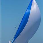
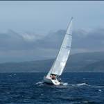
Roaring 40's be roaring...
Have a look at Maatsuyker Island this morning. 59 knot gust!!!!!
www.bom.gov.au/products/IDT60801/IDT60801.94962.shtml
Pressure is dropping about 1 hpa an hour. Now 992 hpa
steep gradient drop, maybe another 20 at Matstyker.
Coming off a low of 945 hPa
I just went and put some more lines on but frankly I would have preferred to secure the boats on the pontoon to windward of me!
Select to expand quotePlanter said..
Maatsuyker + 100k mean for 24hr - Dog and chain gone !!
78 knot gust ffs.... How is the bloody anemometer still attached to the pole?
Below 40 degrees there is no law....
Check out Hogan Island - 87 knot gusts over three observations. Violent Storm F11 gusting to Hurricane F12.
I regularly watch Hogan & the Prom and I believe that the geographical corridor of Bass Strait is at least equal to the windiest region on earth. Even Cape Horn would rarely see those winds (I monitor there too).
Saturday seas on west coast 3-5meters and 7-10 meter swell, so does that mean you could get a 5mtr+ wave on top of a 10mtr+ swell?!
Select to expand quotebullrout said..
Saturday seas on west coast 3-5meters and 7-10 meter swell, so does that mean you could get a 5mtr+ wave on top of a 10mtr+ swell?!
According to the Cape Sorrell bouy chart from last night your question is answered.
There was a 18m peak recorded.
Select to expand quoteJonE said..bullrout said..
Saturday seas on west coast 3-5meters and 7-10 meter swell, so does that mean you could get a 5mtr+ wave on top of a 10mtr+ swell?!
According to the Cape Sorrell bouy chart from last night your question is answered.
There was a 18m peak recorded.
Pretty much!
the bigger problem is the 8m sea on the 7 m swell as both will not be travelling the exact same direction
Looking at weather models, late Saturday night off the SW coast is modelled to be 48 knots (Bf10) gusting 66 with significant wave height of 11m. Remembering SWH is average of top one third, there would be more than a few waves exceeding 11m (36 feet) (and about 3 per day that reach twice SWH). Wave period is modelled as 15s, so 4 per minute. Wind is slightly North of West (277 true) so the SW coast is a lee shore if you're North of South West Cape.
As with a few posters here I have experienced the southern ocean swells. For me during a Westcoaster . We had a 40footer coming up behind our 35 footer for what seemed hours and when we were in the trough and the 40 footer on the crest behind it looked as if he was as high as our mast . At one stage I was wishing he would bear away as I was fearful of him landing on top of us ![]() but he eventually passed with a couple of boat lengths between us.
but he eventually passed with a couple of boat lengths between us.
We live on the east coast of Tas
My son's work on the water 7 days on 7 days off.
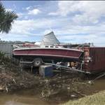
M AST is reporting 6 vessels broke their moorings in the last couple of days...one here... was launched in 1915 and was reportedly the Low Head pilot boat at one stage.
It is now kindling and firewood.
The ' famous ' little blue boat in the River Derwent almost suffered the same fate after being smashed up against a retaining wall for hours.
I suspect more than 6 boats will end up having lost their moorings
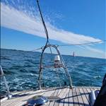
The winds here have been horrendous,
I am glad we no longer have any of our boats in the water, having had our flybridge cruiser sink in similar conditions two years ago but in a weather event that only lasted two days,
This has been going on for weeks
We are over it.
Come on, most winter there has been no wind at all and perfect winter cruising.
Last half of June and first half of July barely got to 15 knots for a month.
and i am way down south.
I will pay the 100 plus knots gust over 4 hours at matsyker last night though
stay safe if not dry.
Select to expand quotelydia said..
I will pay the 100 plus knots gust over 4 hours at matsyker last night though
stay safe if not dry.
Golly. Never seen that before!
90 knots recorded at Low Rocky Point,
17.8 metre wave height recorded on the west coast last week
BOM warning of cyclone type conditions.
State wide marine warnings
State wide flooding warnings.
Emergency powers enacted to force residents to leave flooded areas.
Roads closures due to flooding and/ or dangerous conditions or fallen trees etc etc around the State.
And so on and on and on...
No wonder folk have been ( rightly ) concerned.
Wow, wild weather event for sure. I spent the weekend at 1200 meters on Mt Mawson, running the club ski tow. There were times yesterday, at the top of the tow line, when we had to sit down on the snow to avoid being blown over. It certainly felt like 50+ knots and was particulary painful if you put any bare skin to windward when there was hail embedded in it. I'd better go and check on the boat at Kettering today.
Hi, just hoping everyone is okay down there.
sounds hectic
always remember you can buy another boat but only get one chance at life.
wishing everyone effected only the best