I am setting up a new tablet and want to put a navigation app on it. Previously I have used Navionics. I have noticed that some people are bagging it. I have previously found it quite good. What are you opinions on the best options as far as apps go in Queensland. Thanks...![]()
I run Open Cpn on the computer mostly but also use Navionics on a tablet. I also have paper charts for perusal before we sail and for back up. Navionics is better for the finer detail.
Open Cpn was really nice with a little AIS reciever (Daisy) plugged in. It worked really well and I now am a bit in love with AIS. So I would vote for something you can see the AIS on.
It was blowing dogs off chains a week ago when I was passing Port Kembla. There was a big boat that seemed to be very slowly converging. The AIS gave me their name and MMSI number. I just called them on 16 and had a nice chat to talk about what to do.
Having the AIS tracks show on the chart plotter is a big bonus for me. Massive stress reduction in working out how a big ship is going to affect you.
www.tindie.com/products/astuder/daisy-ais-receiver/
cheers
Phil
I'm setting up a new plotter with a 22 inch monitor and a Dell Wyse running windows 10. Using Seaclear 2 and Open CPN. Both programs run AIS and I shall have to give that daisy system a go. Not overly impressed with Open CPN so far but I'm sure it will become easier and faster. The 1.000 plus page manual is a little daunting!
I have been using iNavX on an ipad the last few years and it works fine, including interfacing with the Raymarine instruments via a wireless link. Pretty sure they are available in android.
Note that I use it as a backup, main nav system is Digiboat's SOB running cmap charts on a windows laptop.
Ilenart
Had C-Map on chart plotter (RNC) and MemoryMap (same RNC as C-Map) on the tablet and the phone. Never had a problem.
I did not use AIS which l regard as an excellent navigational help but perhaps a little over rated for simple coastal piloting far away from busy traffic areas. Bit of a fashion item in most cases, however, it might be a life saver in certain places and situations.
As I am not particularly interested in my neighbours or Wild Oats movements, so l can do without it, yet.![]()
![]()
Last week my mate brought a 40 foot motor cruiser [trawler style] down from Brisbane to Greenwell Point in 2.5 days with an average speed over 8 knots. There was a fair bit of current running. Never used AIS before but now is a true believer! Had a new radar install but was not impressed with this.
I bet he was surprised of the traffic around Newcastle.
All the frightening freighters showing up en-mass, however, nothing is there, what a sailor could not detect if proper watch kept.![]()
Hi Silverback,
I have ISailor on an IPAD and found the software really good. Warning, unlocking 'advanced' features like importing NMEA data over wireless is an extra charge. It's definitely not free and it is up there compared to some apps, but you do get a quality product for your money.
I didn't really mind as I had everything I need unlocked for about $120 including the app and the vector chart 'Torres strait to Sydney'.
Jeppensens, who make Isailor, make ECDIS charts, so the charts are excellent. You log into the store and purchase the map/s you want.
The one problem I have had is that as you zoom out, there is one point where the detail makes the map way too cluttered. You have to zoom in or out one level to clear it up, which is not often but annoying. It's always the same zoom level, so you get used to it.
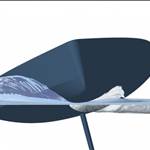
I took a couple of screen shots of Moreton Bay if this is of any interest.
Edit: The red line you can see is my shallow water ("no go zone") in the software, I forgot to turn it off. ![]()


Select to expand quoteshaggybaxter said..
Hi Silverback,
I have ISailor on an IPAD and found the software really good. Warning, unlocking 'advanced' features like importing NMEA data over wireless is an extra charge. It's definitely not free and it is up there compared to some apps, but you do get a quality product for your money.
I didn't really mind as I had everything I need unlocked for about $120 including the app and the vector chart 'Torres strait to Sydney'.
Jeppensens, who make Isailor, make ECDIS charts, so the charts are excellent. You log into the store and purchase the map/s you want.
The one problem I have had is that as you zoom out, there is one point where the detail makes the map way too cluttered. You have to zoom in or out one level to clear it up, which is not often but annoying. It's always the same zoom level, so you get used to it.
I took a couple of screen shots of Moreton Bay if this is of any interest.
Edit: The red line you can see is my shallow water ("no go zone") in the software, I forgot to turn it off. ![]()
Hey Shaggy, as an iSailor devotee I was totally dismayed that after recently being bought out by Wasrtsila, they radically changed their business model /cash in by: converting to annual subscription only (now very expensive) & no longer updating previously purchased charts (although they have responded via a grace period for previous supporters - 6 months). Totally shifted my experience with their product - check out the recent reviews on App Store - they have gone from Hero to Zero & I am personally v uncomfortable with anyone promoting their product/new business model - very disappointed.
r
^^^
I am curious if anybody has developed and supported an 'app' before. I have, a rather basic game/entertainment app and it wasn't cheap and I no longer support it.
Ultimately, app developers develop apps to either support their current business (productivity style of apps) or to make money, either by subscription, a one of payment or through ads. It is becoming more and more expensive and difficult to support. Every time an update is made on an OS, there is a potential your app is no longer supported on that platform. Imagine the noise made after you do an iOS update on your iPad then go sailing to find your preferred nav app is no longer working. Developers are aware of this in advance of course, but it takes people (and often a large team of them) and those people want to get paid for the work they are doing.
I don't begrudge any developer in wanting to charge for their programmes. I would expect the features and support to up there amongst the best though.
Select to expand quoteConcepcion said..shaggybaxter said..
Hi Silverback,
I have ISailor on an IPAD and found the software really good. Warning, unlocking 'advanced' features like importing NMEA data over wireless is an extra charge. It's definitely not free and it is up there compared to some apps, but you do get a quality product for your money.
I didn't really mind as I had everything I need unlocked for about $120 including the app and the vector chart 'Torres strait to Sydney'.
Jeppensens, who make Isailor, make ECDIS charts, so the charts are excellent. You log into the store and purchase the map/s you want.
The one problem I have had is that as you zoom out, there is one point where the detail makes the map way too cluttered. You have to zoom in or out one level to clear it up, which is not often but annoying. It's always the same zoom level, so you get used to it.
I took a couple of screen shots of Moreton Bay if this is of any interest.
Edit: The red line you can see is my shallow water ("no go zone") in the software, I forgot to turn it off. ![]()
Hey Shaggy, as an iSailor devotee I was totally dismayed that after recently being bought out by Wasrtsila, they radically changed their business model /cash in by: converting to annual subscription only (now very expensive) & no longer updating previously purchased charts (although they have responded via a grace period for previous supporters - 6 months). Totally shifted my experience with their product - check out the recent reviews on App Store - they have gone from Hero to Zero & I am personally v uncomfortable with anyone promoting their product/new business model - very disappointed.
r
G'day Concepcion,
Thanks very much, I haven't up to update obviously. Another rent rent money spinner idea...what a shame, I was really growing to love this app.
Appreciate the heads up, I'll go looking it up!
I've had good experience with CMap on OpenCPN, having found no discrepancies from paper charts throughout virtually all of Bass Strait, other than fairly recent mod's to some port leads (PPB Heads etc), which would also be missing from the paper if you hadn't bought them recently or updated per the NTM's.
And one more plug for the dAISy AIS receiver. I bought the dual-channel unit which costs a little more but probably gives a slightly higher chance of receiving a valid signal when things are iffy. My best range (dead calm, big ship with high antenna) was just under 32 nm using the masthead stick, and about 18nm from my homemade pushpit antenna. Typical range is less, greatly influenced by motion of your antenna (waves, heeling), height of target's antenna (little boats, = shorter range) and rain.
I had previously tried the Quark combined AIS/NMEA WiFi muxer (also on Tindie) but it would not send NMEA data over the WiFi so I returned it deeply underwhelmed by both the product and level of support.
Cheers, Graeme
Select to expand quoteConcepcion said..shaggybaxter said..
Hi Silverback,
I have ISailor on an IPAD and found the software really good. Warning, unlocking 'advanced' features like importing NMEA data over wireless is an extra charge. It's definitely not free and it is up there compared to some apps, but you do get a quality product for your money.
I didn't really mind as I had everything I need unlocked for about $120 including the app and the vector chart 'Torres strait to Sydney'.
Jeppensens, who make Isailor, make ECDIS charts, so the charts are excellent. You log into the store and purchase the map/s you want.
The one problem I have had is that as you zoom out, there is one point where the detail makes the map way too cluttered. You have to zoom in or out one level to clear it up, which is not often but annoying. It's always the same zoom level, so you get used to it.
I took a couple of screen shots of Moreton Bay if this is of any interest.
Edit: The red line you can see is my shallow water ("no go zone") in the software, I forgot to turn it off. ![]()
Hey Shaggy, as an iSailor devotee I was totally dismayed that after recently being bought out by Wasrtsila, they radically changed their business model /cash in by: converting to annual subscription only (now very expensive) & no longer updating previously purchased charts (although they have responded via a grace period for previous supporters - 6 months). Totally shifted my experience with their product - check out the recent reviews on App Store - they have gone from Hero to Zero & I am personally v uncomfortable with anyone promoting their product/new business model - very disappointed.
r
they are now offering free unlimited updates on all charts purchased before November 28.
i'm a bit conflicted --- i mostly avoid subscription-based services, which is getting harder and harder to do. at the moment i am on the fence with iSailor as i know it is a lot of work to keep apps updated when new versions of the operating systems and new devices are released every year, and a nav app is the kind of thing that you want to be well-supported by the developers.
forcing yearly fees for all maps is hard to defend though. if i needed more coverage i would probably swap apps, even though iSailor has been great.
Yep, I know what you mean Fishmonkey. You want the product to be quality, but wanting it for free seems a bit self defeating, ie: they won't be around long.
working out a subscription rate that's fair but makes enough revenue is the trick. I'd pay a subscription if it was worth it, but I hope it'd be $20 dollar range , not $200 dollar mark as an annual subscription.
Edit: I'm just gritting my teeth subscribing for boring old Adobe Acrobat. $20 per month! Mongrels.
Thanks everyone. I think I will do the Navionics again and the AIS. Good to see everyone has put forward there opinions. Thanks S
If you are running OpenCPN on a laptop inside you can use a VNC app in Ipad or andriod to share the laptop screen (including functionality) to use the laptop remotely. That is on my previous boat I had a Raspberry Pi using Open CPN and used a samsung tablet to operate it from the helm. Worked reasonaly well, but not as great as a purpose built app (iNavX is my choice), but its free and replicates your existing charts.